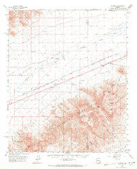
1961 Map of Gladden
USGS Topo · Published 1971About this map
The Harquahala Mountains dominate this arid landscape, rising sharply from the floor of Aguila Valley and Mullen Valley. Recorded in the early 1960s, the map illustrates an era of deep-desert mining and infrastructure development, with numerous workings like the White Marble Mine and the Silver Queen Mine tucked into the canyons. The Atchison Topeka and Santa Fe railroad cuts a straight line across the desert plains, serving small sidings and outposts such as Gladden and Love. This transport corridor was essential for moving minerals and supplies through the heat of the Centennial Wash drainage. Evidence of traveler services and modern utilities appears through labels like Roadside Park and the Eagle Eye Substation, while the surrounding peaks, including Harquahala Mtn and Socorro Peak, provided prominent navigational landmarks for those following the Webber Jeep Trail.
Find a feature on this map
46 named features on this map. Tap any name to fly to it.
Don’t see what you’re looking for? This feature index may not catch every label — zoom into the map to look around manually.
Map Details
Editions of this 1961 Gladden Map
3 editions found

Other maps of this area

1923 · Signal
USGS Topo · 1:250,000

1942 · Signal
USGS Topo · 1:250,000

1942 · Vicksburg
USGS Topo · 1:250,000

1950 · Prescott
USGS Topo · 1:250,000

1954 · Prescott
USGS Topo · 1:250,000

1954 · Phoenix
USGS Topo · 1:250,000

1957 · Phoenix
USGS Topo · 1:250,000

1958 · Prescott
USGS Topo · 1:250,000

1958 · Phoenix
USGS Topo · 1:250,000

1959 · Prescott
USGS Topo · 1:250,000