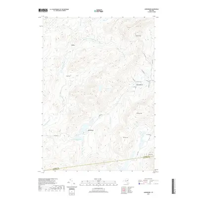
2019 Map of Harrisburg
USGS Topo · Published 2019About this map
Harrisburg stands as a central point in this southern Adirondack region, where local roads like Harrisburg Rd navigate a landscape of high peaks and stream-fed valleys. The settlement pattern is defined by small clusters at Knowelhurst and Fullers, connected by historical routes such as Glassbrook Rd and Seymour Fuller Rd. Water is a defining element of the geography, with Harrisburg Lake and Little Pond situated between high elevations like Bearpen Peak and Wheeler Mtn.
Find a feature on this map
31 named features on this map. Tap any name to fly to it.
Don’t see what you’re looking for? This feature index may not catch every label — zoom into the map to look around manually.
Map Details
Editions of this 2019 Harrisburg Map
This is the sole edition of this map. No revisions or reprints were ever made.
Other maps of this area

1895 · North Creek
USGS Topo · 1:62,500

1897 · North Creek
USGS Topo · 1:62,500

1898 · Thirteenth Lake
USGS Topo · 1:62,500

1903 · Luzerne
USGS Topo · 1:62,500

1910 · Stony Creek
USGS Topo · 1:62,500

1950 · Glens Falls
USGS Topo · 1:250,000

1950 · Utica
USGS Topo · 1:250,000

1954 · Thirteenth Lake
USGS Topo · 1:62,500

1954 · Harrisburg
USGS Topo · 1:62,500
1955 · Lake Luzerne
USGS Topo · 1:62,500