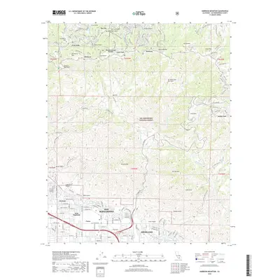
2018 Map of Harrison Mountain
USGS Topo · Published 2018About this map
San Bernardino and Highland sprawl across the southern base of the San Bernardino Mountains, where irrigation and water management infrastructure like the Highland Canal, N Fork Canal, and East Highland Reservoir supported the region's agricultural footprint. To the north, the terrain climbs sharply into the San Bernardino National Forest, revealing a string of mountain communities along the ridgelines. These mountain settlements, including Rimforest, Blue Jay, Skyforest, and Twin Peaks, are connected by a network of winding roads such as Old Toll Rd and Pine Crest Rd. The contrast between the grid-based urban development of Patton and West Highlands and the steep, canyon-cut geography around McKinley Mtn and Harrison Mtn illustrates the geological transition from the valley floor to the high peaks of the San Bernardino Mountains.
Find a feature on this map
158 named features on this map. Tap any name to fly to it.
Don’t see what you’re looking for? This feature index may not catch every label — zoom into the map to look around manually.
Map Details
Editions of this 2018 Harrison Mountain Map
This is the sole edition of this map. No revisions or reprints were ever made.
Other maps of this area

1896 · San Bernardino
USGS Topo · 1:62,500

1898 · San Bernardino
USGS Topo · 1:62,500

1899 · Redlands
USGS Topo · 1:62,500

1901 · Southern California Sheet No. 1
USGS Topo · 1:250,000

1901 · San Bernardino
USGS Topo · 1:62,500

1901 · Redlands
USGS Topo · 1:62,500

1902 · Deep Creek
USGS Topo · 1:62,500

1902 · Hesperia
USGS Topo · 1:62,500

1904 · Southern California Sheet No. 1
USGS Topo · 1:250,000

1936 · Arrowhead
USGS Topo · 1:31,680