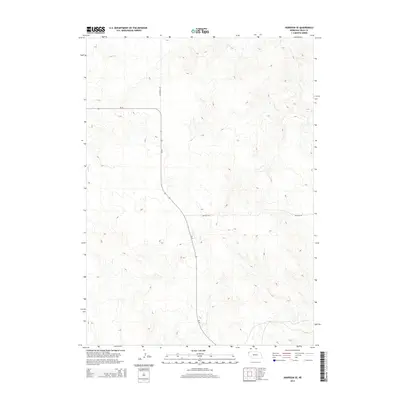
2014 Map of Harrison SE
USGS Topo · Published 2014About this map
State Highway Ne-29 serves as the primary corridor through this high plains landscape in Whistle Creek Precinct, where the terrain is defined by a complex network of ridges and drainages. The rural infrastructure of Sioux County is reflected in the layout of unpaved paths such as Evergreen Rd and Buckley Rd, which provide access to the expansive rangelands typical of this corner of the Nebraska panhandle. This 2014 survey by the U.S. Geological Survey illustrates the intersection of modern road networks with the natural contours of the land, capturing a moment when traditional ranching access remained the dominant human imprint on the topography.
Find a feature on this map
3 named features on this map. Tap any name to fly to it.
Don’t see what you’re looking for? This feature index may not catch every label — zoom into the map to look around manually.
Map Details
Editions of this 2014 Harrison SE Map
This is the sole edition of this map. No revisions or reprints were ever made.
Other maps of this area

1899 · Whistle Creek
USGS Topo · 1:125,000

1955 · Alliance
USGS Topo · 1:250,000

1957 · Alliance
USGS Topo · 1:250,000

1958 · Alliance
USGS Topo · 1:250,000

1978 · Harrison West
USGS Topo · 1:24,000

1979 · Harrison SE
USGS Topo · 1:24,000
1979 · Harrison SW
USGS Topo · 1:24,000
1979 · Agate NW
USGS Topo · 1:24,000

1979 · Agate
USGS Topo · 1:24,000

1979 · Harrison East
USGS Topo · 1:24,000