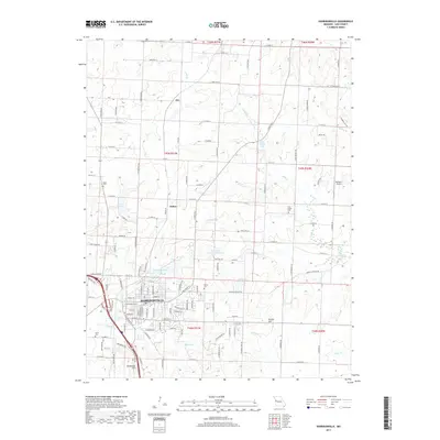
2017 Map of Harrisonville
USGS Topo · Published 2017About this map
Harrisonville serves as the central hub of this Missouri landscape, which is marked by a transition from the town's dense residential grid to the outlying rural reaches of Cass County. The town is surrounded by a series of small water bodies, including City Lake, Lake Luna, and Hanesville Lake, which likely historically supported local infrastructure or recreation. The map illustrates a landscape of agricultural roads and scattered family-named landmarks like Brookhart Hill and Kohler Hill, alongside the smaller settlements of Huber and Ore. To the north and east, the terrain is defined by the winding paths of Camp Br and Crooked Br, feeding into larger water bodies such as Rock Island Lake. Genealogists will find interest in several local burial grounds, notably Orient Cem and Pitts Chapel Cem, which reflect the long-standing community footprint in this part of the state.
Find a feature on this map
123 named features on this map. Tap any name to fly to it.
Don’t see what you’re looking for? This feature index may not catch every label — zoom into the map to look around manually.
Map Details
Editions of this 2017 Harrisonville Map
This is the sole edition of this map. No revisions or reprints were ever made.
Other maps of this area

1887 · Harrisonville
USGS Topo · 1:125,000

1892 · Harrisonville
USGS Topo · 1:125,000

1894 · Harrisonville
USGS Topo · 1:125,000

1947 · Lawrence
USGS Topo · 1:250,000

1950 · Lawrence
USGS Topo · 1:250,000
1953 · Everett
USGS Topo · 1:24,000

1954 · Harrisonville
USGS Topo · 1:24,000
1954 · East Lynne
USGS Topo · 1:24,000
1954 · Raymore
USGS Topo · 1:24,000
1954 · Strasburg
USGS Topo · 1:24,000