
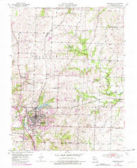
1954 Map of Harrisonville
USGS Topo · Published 1955About this map
Harrisonville stands as a central hub of mid-century Cass County, where the intersection of agriculture and transit is defined by three major rail lines. The Missouri Pacific, St Louis San Francisco, and Kansas Texas railroads converge here, shaping the town's industrial and residential layout. Beyond the city limits, the landscape is dotted with small rural schools like Prairie Dell Sch and Excelsior Sch, alongside many named family cemeteries such as Harris Cem and Glenn Cem.
Find a feature on this map
46 named features on this map. Tap any name to fly to it.
Don’t see what you’re looking for? This feature index may not catch every label — zoom into the map to look around manually.
Map Details
Editions of this 1954 Harrisonville Map
2 editions found
Other maps of this area

1887 · Harrisonville
USGS Topo · 1:125,000

1892 · Harrisonville
USGS Topo · 1:125,000

1894 · Harrisonville
USGS Topo · 1:125,000

1947 · Lawrence
USGS Topo · 1:250,000

1950 · Lawrence
USGS Topo · 1:250,000
1953 · Everett
USGS Topo · 1:24,000
1954 · East Lynne
USGS Topo · 1:24,000
1954 · Raymore
USGS Topo · 1:24,000
1954 · Strasburg
USGS Topo · 1:24,000
1954 · Garden City
USGS Topo · 1:24,000