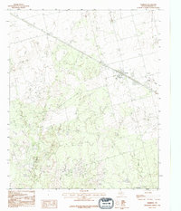
1990 Map of Harrold
USGS Topo · Published 1995About this map
The town of Harrold serves as the focal point of this northern Texas landscape, situated along a primary transportation corridor that remains a central feature of the region's geography. The map reveals a transition from the structured street grid of the settlement to the open drainage basins of several prominent waterways, most notably Rock Creek and China Creek, which wind through the surrounding plains. The local economy is grounded in the presence of Oil extraction sites, reflecting the industrial character common to Wilbarger County in the late 20th century.
Find a feature on this map
9 named features on this map. Tap any name to fly to it.
Don’t see what you’re looking for? This feature index may not catch every label — zoom into the map to look around manually.
Map Details
Editions of this 1990 Harrold Map
This is the sole edition of this map. No revisions or reprints were ever made.
Other maps of this area

1916 · Electra
USGS Topo · 1:24,000

1917 · Beaver Creek
USGS Topo · 1:24,000

1918 · Electra
USGS Topo · 1:31,680

1920 · Beaver Creek
USGS Topo · 1:31,680

1954 · Wichita Falls
USGS Topo · 1:250,000

1955 · Lawton
USGS Topo · 1:250,000

1958 · Wichita Falls
USGS Topo · 1:250,000

1958 · Davidson
USGS Topo · 1:62,500

1958 · Electra
USGS Topo · 1:62,500

1966 · Grayback
USGS Topo · 1:24,000