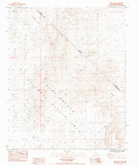
1984 Map of Hart Peak
USGS Topo · Published 1984About this map
Hart (Site) sits at the heart of this desert landscape, a location marked by the remnants of mining activity and the presence of a Cem. The terrain is dominated by the Castle Mountains and Hart Peak, where numerous Prospects and an Open Pit mine indicate the area's mineral-driven history. The map preserves the Von Schmidt Line (1873), an important cadastral boundary marking the early survey of the Nevada California border. Water, the most critical resource in this arid environment, is pinpointed at scattered locations like Lewis Holes, Kennedy Well, and Stagecoach Well. These features, along with the Piute Range, illustrate the challenges of 19th-century desert travel and the specific hubs where miners and ranchers managed to establish a foothold in the East Mojave National Scenic Area.
Find a feature on this map
23 named features on this map. Tap any name to fly to it.
Don’t see what you’re looking for? This feature index may not catch every label — zoom into the map to look around manually.
Map Details
Editions of this 1984 Hart Peak Map
2 editions found
Other maps of this area

1886 · Camp Mohave
USGS Topo · 1:250,000

1892 · Camp Mohave
USGS Topo · 1:250,000

1910 · Ivanpah
USGS Topo · 1:250,000

1912 · Ivanpah
USGS Topo · 1:250,000

1926 · Mohave City
USGS Topo · 1:96,000

1942 · Camp Mohave
USGS Topo · 1:250,000

1942 · Ivanpah
USGS Topo · 1:250,000

1947 · Kingman
USGS Topo · 1:250,000

1948 · Kingman
USGS Topo · 1:250,000

1954 · Kingman
USGS Topo · 1:250,000