
1945 Map of Hartford North
USGS Topo · Published 1945About this map
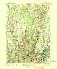
The Connecticut River dominates the eastern half of this landscape, separating the core of Hartford from East Hartford. This wartime-era survey reveals a densely developed capital city characterized by a significant concentration of religious and educational institutions, including the Hartford Seminary Foundation, the American School For The Deaf, and the St Josephs College. The city's northern reaches transition into the rolling terrain of Bloomfield and Windsor, where the New York New Haven and Hartford RR traces the river's western bank.
Find a feature on this map
107 named features on this map. Tap any name to fly to it.
Don’t see what you’re looking for? This feature index may not catch every label — zoom into the map to look around manually.
Map Details
Editions of this 1945 Hartford North Map
2 editions found
Other maps of this area

1892 · Hartford
USGS Topo · 1:62,500

1892 · Meriden
USGS Topo · 1:62,500

1892 · Granby
USGS Topo · 1:62,500

1893 · Middletown
USGS Topo · 1:62,500

1893 · Meriden
USGS Topo · 1:62,500

1906 · Farmington
USGS Topo · 1:125,000

1928 · Windsor Locks
USGS Topo · 1:24,000

1928 · Windsor
USGS Topo · 1:24,000

1928 · Glastonbury
USGS Topo · 1:24,000

1928 · Broad Brook
USGS Topo · 1:24,000