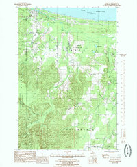
1985 Map of Harvey
USGS Topo · Published 1985About this map
Lake Superior shorelines define the northern edge of this 1980s-era landscape, where the Chocolay River winds through the townships of Chocolay and West Branch. The settlement pattern follows a transition from the lakeside community of Harvey and Lakewood to more specialized rural landmarks further inland. Notable institutional and industrial sites include the Mangum Prison Farm and a Fish Hatchery located near Cherry Creek. Local history is anchored by Green Garden and its religious center at St Pauls Ch and St Pauls Cem. Large swaths of the Escanaba River State Forest dominate the western portion of the sheet, while an Old RR Grade cuts through the center, marking the path of former transport routes that once served the timber and mining interests of the Upper Peninsula.
Find a feature on this map
49 named features on this map. Tap any name to fly to it.
Don’t see what you’re looking for? This feature index may not catch every label — zoom into the map to look around manually.
Map Details
Editions of this 1985 Harvey Map
This is the sole edition of this map. No revisions or reprints were ever made.
Other maps of this area

1907 · Marquette
USGS Topo · 1:62,500

1932 · Skandia SW
USGS Topo · 1:31,680

1932 · Harvey NW
USGS Topo · 1:31,680

1932 · Harvey SE
USGS Topo · 1:31,680

1932 · Harvey SW
USGS Topo · 1:31,680

1932 · Harvey NE
USGS Topo · 1:31,680

1950 · Skandia NW
USGS Topo · 1:31,680

1952 · Sands
USGS Topo · 1:24,000

1952 · Gwinn
USGS Topo · 1:62,500

1952 · Gwinn
USGS Topo · 1:24,000