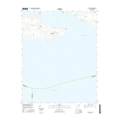
2016 Map of Harvey Neck
USGS Topo · Published 2016About this map
Harvey Neck and the surrounding coastal waters define this section of the Albemarle Sound region. This coastal landscape is dominated by the strategic Harvey Point Defense Testing Activity Airport, a facility situated on the peninsula between the Perquimans River and the sound. The presence of the Harvey Cem near the point serves as a small but significant link to the long-standing family history of this shoreline, while named landforms like Blount Point, Piney Point, and Harvey Point mark the irregular, marshy coast. Local roads such as Muddy Creek Rd and Cross Neck Rd connect the scattered residential pockets of Durants Neck, illustrating the remote, water-oriented character of this part of North Carolina.
Find a feature on this map
22 named features on this map. Tap any name to fly to it.
Don’t see what you’re looking for? This feature index may not catch every label — zoom into the map to look around manually.
Map Details
Editions of this 2016 Harvey Neck Map
This is the sole edition of this map. No revisions or reprints were ever made.
Other maps of this area

1906 · Hertford
USGS Topo · 1:62,500

1940 · Hertford
USGS Topo · 1:62,500

1940 · Wade Point
USGS Topo · 1:62,500

1943 · Wade Point
USGS Topo · 1:62,500

1943 · Columbia
USGS Topo · 1:125,000

1948 · Wade Point
USGS Topo · 1:62,500

1953 · Norfolk
USGS Topo · 1:250,000

1953 · Columbia East
USGS Topo · 1:24,000

1953 · Columbia West
USGS Topo · 1:24,000

1953 · Rocky Mount
USGS Topo · 1:250,000