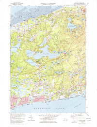
1974 Map of Harwich
USGS Topo · Published 1976About this map
Glacial kettle ponds and coastal villages define this mid-1970s landscape of the Lower Cape. The transition from the tranquil shores of Cape Cod Bay to the busy harbors of the Nantucket Sound is marked by a dense concentration of freshwater bodies, including Long Pond, Cliff Pond, and Seymour Pond. Settlement patterns follow the historic corridors of the Old King's Highway through Brewster and the rail line of the Penn Central, which connects the inland villages of North Harwich and Pleasant Lake.
Find a feature on this map
113 named features on this map. Tap any name to fly to it.
Don’t see what you’re looking for? This feature index may not catch every label — zoom into the map to look around manually.
Map Details
Editions of this 1974 Harwich Map
Other maps of this area

1887 · Wellfleet
USGS Topo · 1:62,500

1887 · Yarmouth
USGS Topo · 1:62,500

1888 · Chatham
USGS Topo · 1:62,500

1889 · Yarmouth
USGS Topo · 1:62,500

1889 · Wellfleet
USGS Topo · 1:62,500

1893 · Chatham
USGS Topo · 1:62,500

1893 · Yarmouth
USGS Topo · 1:62,500

1893 · Wellfleet
USGS Topo · 1:62,500

1917 · Chatham
USGS Topo · 1:62,500

1942 · Cape Cod Bay
USGS Topo · 1:125,000