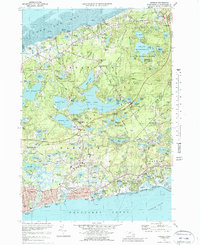
1974 Map of Harwich
USGS Topo · Published 1988About this map
The coastal transition from the Nantucket Sound to Cape Cod Bay is illustrated here, revealing a landscape defined by glacial kettle ponds and early transportation corridors. The network of interior waterways, including the expansive Long Pond, Seymour Pond, and Hinckleys Pond, serves as a backdrop to the area's mid-20th-century development. While the Railroad Grade and Old Railroad Grade indicate the importance of former rail lines to the region's economy, newer institutions like the Cape Cod Regional Technical High Sch and Cranberry Valley Municipal Country Club reflect the shifting land use toward education and recreation. Coastal settlements from Harwich Port to Dennis Port anchor the southern shoreline, while Nickerson State Forest Park preserves significant open space to the north, containing numerous smaller basins like Cliff Pond and Flax Pond.
Find a feature on this map
125 named features on this map. Tap any name to fly to it.
Don’t see what you’re looking for? This feature index may not catch every label — zoom into the map to look around manually.
Map Details
Editions of this 1974 Harwich Map
Other maps of this area

1887 · Wellfleet
USGS Topo · 1:62,500

1887 · Yarmouth
USGS Topo · 1:62,500

1888 · Chatham
USGS Topo · 1:62,500

1889 · Yarmouth
USGS Topo · 1:62,500

1889 · Wellfleet
USGS Topo · 1:62,500

1893 · Chatham
USGS Topo · 1:62,500

1893 · Yarmouth
USGS Topo · 1:62,500

1893 · Wellfleet
USGS Topo · 1:62,500

1917 · Chatham
USGS Topo · 1:62,500

1942 · Cape Cod Bay
USGS Topo · 1:125,000