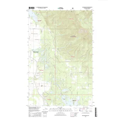
2017 Map of Hash Mountain
USGS Topo · Published 2017About this map
The Swan Range dominates the eastern landscape of this Flathead County quadrangle, where high peaks like Hash Mtn and Peters Ridge give way to the lowlands of the Flathead Valley. This 2017 survey shows a complex web of glacial and alpine water bodies, ranging from the large Lake Blaine in the north to the cluster of small lakes near the Creston National Fish Hatchery. The density of water features, including Jessup Mill Pond, John Lake, and Tamarack Lake, indicates a geography defined by post-glacial deposition and modern conservation efforts. At the southern edge, the settlement of Bigfork sits near Echo Lake, while the Creston Cemetery provides a point of genealogical interest in the western flats. The transition from the managed timberlands of the Flathead National Forest to the residential development along Foothill RD and Many Lakes DR illustrates the intersection of wilderness and settlement in modern Montana.
Find a feature on this map
142 named features on this map. Tap any name to fly to it.
Don’t see what you’re looking for? This feature index may not catch every label — zoom into the map to look around manually.
Map Details
Editions of this 2017 Hash Mountain Map
This is the sole edition of this map. No revisions or reprints were ever made.
Other maps of this area

1914 · Nyack
USGS Topo · 1:125,000

1943 · Kalispell
USGS Topo · 1:125,000

1957 · Kalispell
USGS Topo · 1:250,000

1960 · Kalispell
USGS Topo · 1:250,000

1960 · Cut Bank
USGS Topo · 1:250,000

1961 · Kalispell
USGS Topo · 1:250,000

1962 · Columbia Falls South
USGS Topo · 1:24,000

1962 · Doris Mountain
USGS Topo · 1:24,000

1962 · Somers
USGS Topo · 1:24,000

1962 · Creston
USGS Topo · 1:24,000