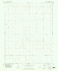
1974 Map of Haswell SE
USGS Topo · Published 1978About this map
Spanning the high plains border between Kiowa Co and Bent Co, this topographic survey captures a quiet agricultural landscape defined more by historical infrastructure than dense settlement. The most prominent human feature is the long Old Railroad Grade that cuts diagonally across the eastern sections, a vestige of mid-century transport that once connected this remote region to larger rail hubs. A single Radio Tower stands as a modern marker near the center of the sheet, while Potters Lake provides a rare water feature in this arid environment. The map shows the orderly section lines and field boundaries characteristic of Colorado's eastern plains, offering a precise view of land ownership and surveyor markers from the early 1970s.
Find a feature on this map
4 named features on this map. Tap any name to fly to it.
Don’t see what you’re looking for? This feature index may not catch every label — zoom into the map to look around manually.
Map Details
Editions of this 1974 Haswell SE Map
This is the sole edition of this map. No revisions or reprints were ever made.
Other maps of this area

1891 · Las Animas
USGS Topo · 1:125,000

1892 · Lamar
USGS Topo · 1:125,000

1893 · Las Animas
USGS Topo · 1:125,000

1954 · Lamar
USGS Topo · 1:250,000

1955 · Tree Top Ranch
USGS Topo · 1:24,000

1955 · Lubers
USGS Topo · 1:24,000

1955 · Bishop Ranch
USGS Topo · 1:24,000

1958 · Lamar
USGS Topo · 1:250,000

1968 · Rose Ranch
USGS Topo · 1:24,000

1968 · Hawkins
USGS Topo · 1:24,000