
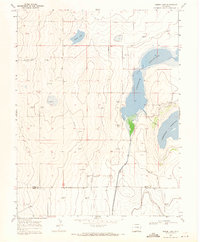
1968 Map of Rose Ranch
USGS Topo · Published 1971About this map
Rose Ranch sits at the heart of this late-1960s landscape where Kiowa and Bent counties meet. The terrain is defined by wide open expanses and subtle depressions, marked by essential water sources such as Government Spring and a solitary Well. The presence of the Aqueduct in the southwest corner and a remote Drill Hole to the northeast suggests a landscape where water management and resource exploration were paramount to local survival and industry. Educational needs for the scattered ranching families were served by the Prairie Center School, located in the northern reaches of the survey area. This map documents a period when rural infrastructure was tied to small, localized centers of community and industry before the further consolidation of modern ranching operations.
Find a feature on this map
8 named features on this map. Tap any name to fly to it.
Don’t see what you’re looking for? This feature index may not catch every label — zoom into the map to look around manually.
Map Details
Editions of this 1968 Rose Ranch Map
This is the sole edition of this map. No revisions or reprints were ever made.
Other maps of this area

1891 · Las Animas
USGS Topo · 1:125,000

1892 · Lamar
USGS Topo · 1:125,000

1893 · Las Animas
USGS Topo · 1:125,000

1954 · Lamar
USGS Topo · 1:250,000

1955 · McClave
USGS Topo · 1:24,000

1955 · Tree Top Ranch
USGS Topo · 1:24,000

1955 · Lubers
USGS Topo · 1:24,000

1958 · Lamar
USGS Topo · 1:250,000
1968 · Swede Lake
USGS Topo · 1:24,000

1968 · Hawkins
USGS Topo · 1:24,000