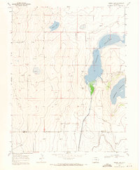
1968 Map of Swede Lake
USGS Topo · Published 1971About this map
The high plains of Southeast Colorado are defined here by a sophisticated network of irrigation and storage, capturing the landscape as it appeared in the late 1960s. Large water bodies including Neesopah Reservoir and Neegronda Reservoir dominate the eastern half of the terrain, fed and managed through an extensive system of waterways like the Kicking Bird Canal and Fort Lyon Canal. These features highlight the critical role of water management in this arid region, where even smaller features like Swede Lake provide essential landmarks.
Find a feature on this map
14 named features on this map. Tap any name to fly to it.
Don’t see what you’re looking for? This feature index may not catch every label — zoom into the map to look around manually.
Map Details
Editions of this 1968 Swede Lake Map
This is the sole edition of this map. No revisions or reprints were ever made.
Other maps of this area

1892 · Lamar
USGS Topo · 1:125,000

1954 · Lamar
USGS Topo · 1:250,000

1955 · McClave
USGS Topo · 1:24,000

1955 · Lubers
USGS Topo · 1:24,000

1955 · Wiley
USGS Topo · 1:24,000

1958 · Lamar
USGS Topo · 1:250,000

1967 · Neenoshe Reservoir
USGS Topo · 1:24,000

1968 · Rose Ranch
USGS Topo · 1:24,000
1968 · Alkali Lake
USGS Topo · 1:24,000

1968 · Hawkins
USGS Topo · 1:24,000