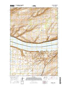
2017 Map of Hat Rock
USGS Topo · Published 2017About this map
The Columbia River defines the border between Oregon and Washington in this recent survey of the Umatilla region. The landscape is marked by the expansive waters of Lake Wallula, created by downstream damming, which has reshaped the original riverbank. Along the southern shore, the distinctive geological formation of Hat Rock stands near the small community of River View, while the nearby Boat Rock serves as another prominent landmark for navigation and local history.
Find a feature on this map
31 named features on this map. Tap any name to fly to it.
Don’t see what you’re looking for? This feature index may not catch every label — zoom into the map to look around manually.
Map Details
Editions of this 2017 Hat Rock Map
This is the sole edition of this map. No revisions or reprints were ever made.
Other maps of this area

1908 · Umatilla
USGS Topo · 1:125,000

1917 · Pasco
USGS Topo · 1:125,000

1953 · Pendleton
USGS Topo · 1:250,000

1953 · Walla Walla
USGS Topo · 1:250,000

1956 · Pendleton
USGS Topo · 1:250,000

1958 · Walla Walla
USGS Topo · 1:250,000

1962 · Hat Rock
USGS Topo · 1:24,000

1962 · Stanfield
USGS Topo · 1:24,000

1962 · Hermiston
USGS Topo · 1:24,000

1962 · Juniper
USGS Topo · 1:24,000