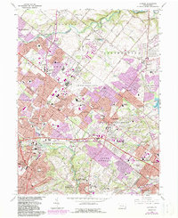
1966 Map of Hatboro
USGS Topo · Published 1983About this map
Hatboro and its surrounding townships show a landscape in rapid transition as suburban development spreads across the Bucks and Montgomery County line. The mid-century expansion of urban areas is evident in the purple-tinted corridors of Warminster, Southampton, and Feasterville, where residential subdivisions like Rosewood Park and Lacey Park flank the historic core. A significant military footprint is visible at the US Naval Air Development Center, which occupies a large central tract between Ivyland and Davisville.
Find a feature on this map
94 named features on this map. Tap any name to fly to it.
Don’t see what you’re looking for? This feature index may not catch every label — zoom into the map to look around manually.
Map Details
Editions of this 1966 Hatboro Map
Other maps of this area

1890 · Lambertville
USGS Topo · 1:62,500

1890 · Doylestown
USGS Topo · 1:62,500

1890 · Burlington
USGS Topo · 1:62,500

1891 · Lambertville
USGS Topo · 1:62,500

1891 · Doylestown
USGS Topo · 1:62,500

1893 · Germantown
USGS Topo · 1:62,500

1893 · Burlington
USGS Topo · 1:62,500

1894 · Lambertville
USGS Topo · 1:62,500

1894 · Germantown
USGS Topo · 1:62,500

1896 · Germantown
USGS Topo · 1:62,500
Featured Places
- Philadelphia, PA
- Abington Township, PA
- Warminster Township, PA
- Horsham Township, PA
- Warrington Township, PA