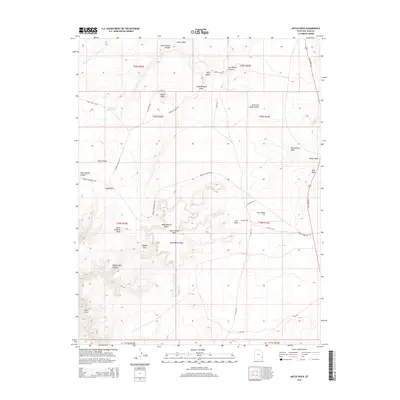
2014 Map of Hatch Rock
USGS Topo · Published 2014About this map
Hatch Rock and the high plateaus of San Juan County dominate this terrain, where the landscape is defined by deep incisions like Hatch Ranch Canyon and Bobbys Hole Canyon. This 2014 survey documents a network of named landmarks and water catchments essential for navigating the high desert, including Little Rock Reservoir and the distinctive The Tank near the eastern edge of the quadrangle. The naming conventions throughout the area, such as Soup Rock, Jail Rock, and Rone Bailey Mesa, reflect a history of local identification used by ranchers and early travelers. Transportation is centered on N Highway 191, which provides access to more remote routes like Needles Overlook Rd and Looking Glass Rd, connecting these geological landmarks to the broader regional infrastructure.
Find a feature on this map
35 named features on this map. Tap any name to fly to it.
Don’t see what you’re looking for? This feature index may not catch every label — zoom into the map to look around manually.
Map Details
Editions of this 2014 Hatch Rock Map
This is the sole edition of this map. No revisions or reprints were ever made.
Other maps of this area

1885 · La Sal
USGS Topo · 1:250,000

1954 · Mt Peale 3 NW
USGS Topo · 1:24,000

1954 · Mt Peale 3 SW
USGS Topo · 1:24,000

1954 · Mt Peale 3 NE
USGS Topo · 1:24,000

1954 · Mt Peale 3 SE
USGS Topo · 1:24,000

1954 · Mt Peale 2 SW
USGS Topo · 1:24,000

1954 · Mt Peale 2 SE
USGS Topo · 1:24,000
1954 · Carlisle 4 SE
USGS Topo · 1:24,000

1954 · Carlisle 1 SE
USGS Topo · 1:24,000

1954 · Carlisle 4 NE
USGS Topo · 1:24,000