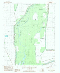
1983 Map of Hatchie Coon
USGS Topo · Published 1984About this map
The St Francis Sunken Lands State Wildlife Management Area dominates this landscape, reflecting the unique geography formed during the New Madrid earthquakes. This 1980s-era survey details a complex system of water management and drainage along the St Francis River, including the Hatchie Coon Floodway and numerous numbered ditches like Ditch No 31 and Ditch No 32. These man-made channels cut through the alluvial bottomlands, supporting the surrounding agricultural operations of Maumelle Prairie.
Find a feature on this map
48 named features on this map. Tap any name to fly to it.
Don’t see what you’re looking for? This feature index may not catch every label — zoom into the map to look around manually.
Map Details
Editions of this 1983 Hatchie Coon Map
This is the sole edition of this map. No revisions or reprints were ever made.
Other maps of this area

1939 · Jonesboro
USGS Topo · 1:62,500

1940 · Dee
USGS Topo · 1:62,500

1941 · Leachville
USGS Topo · 1:62,500

1941 · Marked Tree
USGS Topo · 1:62,500

1953 · Memphis
USGS Topo · 1:250,000

1956 · Leachville
USGS Topo · 1:62,500

1956 · Marked Tree
USGS Topo · 1:62,500

1956 · Memphis
USGS Topo · 1:250,000

1958 · Dee
USGS Topo · 1:62,500

1958 · Jonesboro
USGS Topo · 1:62,500