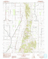
1983 Map of Greenfield
USGS Topo · Published 1984About this map
Crowleys Ridge dominates the center of this landscape, creating a narrow band of elevated, complex terrain that stands in stark contrast to the surrounding flat alluvial plains. This geological formation serves as a natural divide between the drainage systems of the L'Anguille River to the southwest and the managed agricultural ditches to the east, including the Main Spoil Bank Ditch and Viney Slough.
Find a feature on this map
19 named features on this map. Tap any name to fly to it.
Don’t see what you’re looking for? This feature index may not catch every label — zoom into the map to look around manually.
Map Details
Editions of this 1983 Greenfield Map
This is the sole edition of this map. No revisions or reprints were ever made.
Other maps of this area

1935 · Sedgwick
USGS Topo · 1:62,500

1939 · Weiner
USGS Topo · 1:62,500

1939 · Jonesboro
USGS Topo · 1:62,500

1940 · Dee
USGS Topo · 1:62,500

1953 · Memphis
USGS Topo · 1:250,000

1956 · Memphis
USGS Topo · 1:250,000

1958 · Dee
USGS Topo · 1:62,500

1958 · Jonesboro
USGS Topo · 1:62,500

1959 · Weiner
USGS Topo · 1:62,500

1959 · Sedgwick
USGS Topo · 1:62,500