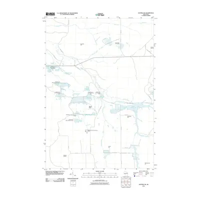
2010 Map of Hatfield SE
USGS Topo · Published 2010About this map
The Crawford Hills and prominent elevations like Wildcat Mound define this Jackson County landscape, characterized by an intricate network of managed water bodies. This 2010 survey highlights a significant history of land and water management, evidenced by numerous dams attributed to the Resettlement Administration. These structures, including the Resettlement Administration 12 Dam and Resettlement Administration 15 Dam, created a series of named wetlands and reservoirs such as White Tail Flowage, Partridge Crop Flowage, and Seventeen Reservoir. The area around Speck Oaks and the expansive Potter Flowage 58 showcases the complexity of the local drainage system, where Morrison Creek and Town Line Creek wind through a terrain marked by scattered hills like Wangreen Hill and Circle Hill. This map is a record of environmental engineering and conservation efforts in the central Wisconsin wetlands.
Find a feature on this map
52 named features on this map. Tap any name to fly to it.
Don’t see what you’re looking for? This feature index may not catch every label — zoom into the map to look around manually.
Map Details
Editions of this 2010 Hatfield SE Map
This is the sole edition of this map. No revisions or reprints were ever made.
Other maps of this area

1947 · Millston
USGS Topo · 1:62,500

1949 · Millston
USGS Topo · 1:62,500

1953 · Eau Claire
USGS Topo · 1:250,000

1957 · City Point
USGS Topo · 1:48,000

1958 · Eau Claire
USGS Topo · 1:250,000

1958 · Hatfield
USGS Topo · 1:48,000

1958 · Wyeville
USGS Topo · 1:48,000

1964 · Eau Claire
USGS Topo · 1:250,000
1970 · Hatfield SW
USGS Topo · 1:24,000

1970 · Spaulding
USGS Topo · 1:24,000