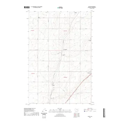
2020 Map of Hatton
USGS Topo · Published 2020About this map
Hatton and Cunningham anchor this high-desert landscape in Adams County, where the topography is defined by the unique geological cuts of the Channeled Scablands. The map reveals a highly structured grid of section lines and gravel roads, including Lind-Hatton Rd and Kulm Rd Se, which cross the undulating expanse of the Kansas Prairie. The terrain is deeply inscribed by coulees—steep-walled, dry canyons formed by ancient glacial floods—most notably Providence Coulee in the north and the namesake Hatton Coulee which skirts the southern edge of the town of Hatton. The concentration of transportation infrastructure, such as Neilson Rd and Pence Rd, follows these natural drainage corridors, illustrating how the regional topography dictated the development of travel routes between small agricultural hubs.
Find a feature on this map
32 named features on this map. Tap any name to fly to it.
Don’t see what you’re looking for? This feature index may not catch every label — zoom into the map to look around manually.
Map Details
Editions of this 2020 Hatton Map
This is the sole edition of this map. No revisions or reprints were ever made.
Other maps of this area

1916 · Connell
USGS Topo · 1:125,000

1918 · Connell
USGS Topo · 1:125,000

1953 · Walla Walla
USGS Topo · 1:250,000

1958 · Walla Walla
USGS Topo · 1:250,000
1970 · Frischknecht
USGS Topo · 1:24,000

1970 · Lind SW
USGS Topo · 1:24,000
1970 · Shano
USGS Topo · 1:24,000
1970 · Roxboro
USGS Topo · 1:24,000
1970 · Providence
USGS Topo · 1:24,000
1970 · Connell
USGS Topo · 1:24,000