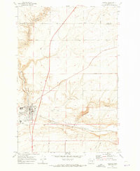
1970 Map of Connell
USGS Topo · Published 1973About this map
Connell serves as the central hub of this eastern Washington landscape, where the confluence of major transportation and agricultural infrastructure is evident. The town is marked by the presence of its High Sch, a Connell Airport, and local industry indicated by a Grain Elevator and several gravel pits. This 1970 field-checked survey highlights the significance of the rail corridor, showing the tracks of the Burlington Northern and Northern Pacific winding through the dramatic natural topography. The terrain is dominated by ancient basaltic flood-carved features, including Providence Coulee and the massive Washtucna (Depression) Coulee to the south. Named local roads like Roxboro Road and Fishhook Elgin Road provide a grid of access to the surrounding dryland farming plateaus, while smaller landmarks like the Nordheim area and various gaging stations point to the managed water and land use of the Franklin County region.
Find a feature on this map
37 named features on this map. Tap any name to fly to it.
Don’t see what you’re looking for? This feature index may not catch every label — zoom into the map to look around manually.
Map Details
Editions of this 1970 Connell Map
This is the sole edition of this map. No revisions or reprints were ever made.
Other maps of this area

1916 · Connell
USGS Topo · 1:125,000

1918 · Connell
USGS Topo · 1:125,000

1953 · Walla Walla
USGS Topo · 1:250,000

1958 · Walla Walla
USGS Topo · 1:250,000
1970 · Burr Canyon
USGS Topo · 1:24,000
1970 · Mesa East
USGS Topo · 1:24,000
1970 · Frischknecht
USGS Topo · 1:24,000

1970 · Lind SW
USGS Topo · 1:24,000
1970 · Shano
USGS Topo · 1:24,000
1970 · Connell SE
USGS Topo · 1:24,000