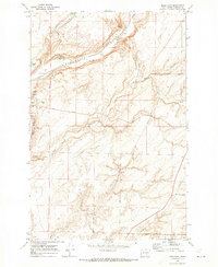
1970 Map of Mesa East
USGS Topo · Published 1973About this map
Esquatzel Coulee defines the drainage and transit geography of this Franklin County landscape, providing a natural corridor for the Burlington Northern railroad lines. The small settlement of Mesa sits at the western edge of the quadrangle, serving as a hub for the surrounding agricultural community. The terrain is marked by distinctive geological features including Old Maid Coulee, Cactus Coulee, and Dunnigan Coulee, which weave through the high ground.
Find a feature on this map
19 named features on this map. Tap any name to fly to it.
Don’t see what you’re looking for? This feature index may not catch every label — zoom into the map to look around manually.
Map Details
Editions of this 1970 Mesa East Map
This is the sole edition of this map. No revisions or reprints were ever made.
Other maps of this area

1915 · Wallulah
USGS Topo · 1:96,000

1916 · Connell
USGS Topo · 1:125,000

1917 · Pasco
USGS Topo · 1:125,000

1918 · Connell
USGS Topo · 1:125,000

1918 · Wallula
USGS Topo · 1:125,000

1925 · Scooteney Lake
USGS Topo · 1:62,500

1951 · Scooteney Lake
USGS Topo · 1:62,500

1953 · Walla Walla
USGS Topo · 1:250,000

1958 · Walla Walla
USGS Topo · 1:250,000

1963 · Rye Grass Coulee
USGS Topo · 1:24,000