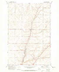
1970 Map of Hatton
USGS Topo · Published 1973About this map
Hatton serves as the primary rail-and-agricultural hub on this eastern Washington survey, situated at the confluence of several geological drainages. The landscape is defined by the Kansas Prairie and carved by prominent dry coulees, including Providence Coulee, Cunningham Coulee, and Hatton Coulee. These features dictate the placement of transportation infrastructure, most notably the Burlington Northern railroad which runs north-south through the terrain. The local economy is visibly centered on grain storage and transit, with several Grain Elevators and industrial Storage Bins clustered near the town site. An extensive network of rural roads, such as Damon Road and Foley Road, creates a grid across the agricultural allotments, connecting the various grain-handling facilities and a Gaging Station to the broader region during this era of post-war farming expansion.
Find a feature on this map
24 named features on this map. Tap any name to fly to it.
Don’t see what you’re looking for? This feature index may not catch every label — zoom into the map to look around manually.
Map Details
Editions of this 1970 Hatton Map
This is the sole edition of this map. No revisions or reprints were ever made.
Other maps of this area

1916 · Connell
USGS Topo · 1:125,000

1918 · Connell
USGS Topo · 1:125,000

1953 · Walla Walla
USGS Topo · 1:250,000

1958 · Walla Walla
USGS Topo · 1:250,000
1970 · Frischknecht
USGS Topo · 1:24,000

1970 · Lind SW
USGS Topo · 1:24,000
1970 · Shano
USGS Topo · 1:24,000
1970 · Roxboro
USGS Topo · 1:24,000
1970 · Providence
USGS Topo · 1:24,000
1970 · Connell
USGS Topo · 1:24,000