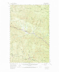
1957 Map of Haugan
USGS Topo · Published 1967About this map
The St Regis River corridor serves as the primary artery for transportation and settlement in this 1957 survey of the Montana-Idaho borderlands. Small communities such as Haugan, De Borgia, and Henderson are strung along the valley, anchored by the competing lines of the Chicago Milwaukee St Paul and Pacific and the Northern Pacific railroads. The map documents an era when the mountain extraction economy was deeply embedded in the landscape, shown through numerous mining operations like the Saranac Consolidated Mine and Rock Island Mine tucked into the steep drainages.
Find a feature on this map
95 named features on this map. Tap any name to fly to it.
Don’t see what you’re looking for? This feature index may not catch every label — zoom into the map to look around manually.
Map Details
Editions of this 1957 Haugan Map
2 editions found

Other maps of this area

1914 · Avery
USGS Topo · 1:125,000

1917 · Avery
USGS Topo · 1:125,000

1918 · St Regis
USGS Topo · 1:125,000

1919 · St. Regis
USGS Topo · 1:125,000

1932 · Trout Creek
USGS Topo · 1:125,000

1935 · Trout Creek
USGS Topo · 1:125,000

1936 · Trout Creek
USGS Topo · 1:125,000

1937 · Thompson Falls
USGS Topo · 1:125,000

1937 · Thompson Falls
USGS Topo · 1:62,500

1956 · Cooper Gulch
USGS Topo · 1:62,500