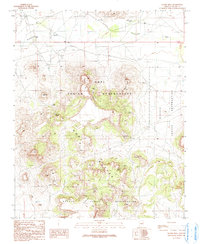
1991 Map of Hauke Mesa
USGS Topo · Published 1991About this map
The Hopi Indian Reservation and the Navajo Indian Reservation meet across a landscape dominated by the volcanic forms of the Hopi Buttes. This 1991 provisional map highlights a high-elevation environment defined by prominent landmarks like Hauke Mesa, Bell Butte, and Horse Butte. Water sources are critical features in this arid region, marked by numerous named springs such as Shontah Spring, Ram Spring, and Lukai Spring, as well as the Betony Reservoir. The presence of a Cemetery and multiple Graves near the washes in the northern and eastern sections provides specific points of interest for genealogists and local historians. The map also records the network of Check Dams along the Ha-whi-yalin Wash, illustrating late 20th-century water management efforts across these ancestral lands.
Find a feature on this map
25 named features on this map. Tap any name to fly to it.
Don’t see what you’re looking for? This feature index may not catch every label — zoom into the map to look around manually.
Map Details
Editions of this 1991 Hauke Mesa Map
This is the sole edition of this map. No revisions or reprints were ever made.
Other maps of this area

1883 · Tusayan
USGS Topo · 1:250,000

1886 · Tusayan
USGS Topo · 1:250,000

1947 · Flagstaff
USGS Topo · 1:250,000

1954 · Flagstaff
USGS Topo · 1:250,000

1958 · Flagstaff
USGS Topo · 1:250,000

1960 · Flagstaff
USGS Topo · 1:250,000

1962 · Flagstaff
USGS Topo · 1:250,000

1966 · White Cone
USGS Topo · 1:62,500

1966 · Egloffstein Butte
USGS Topo · 1:62,500
1967 · Dilkon
USGS Topo · 1:24,000