1966 Map of White Cone
USGS Topo · Published 1968About this map
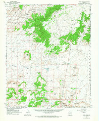
Hopi Indian Reservation and Navajo Indian Reservation lands dominate this mid-century survey, defined by the distinct mesas and volcanic buttes that rise from the desert floor. The landscape is marked by the Joint Use Area Boundary, a significant geopolitical designation of the era. Prominent landmarks such as Stephen Butte, White Cone Peak, and the long stretches of First Flat Mesa and Second Flat Mesa provide a clear view of the high-elevation terrain. Life and movement in this arid environment are traced through essential water sources like Jadito Spring, Coyote Spring, and White Cone Spring, alongside seasonal drainage networks including Jadito Wash and Ha-whi-yalin Wash. Scattered Water Tanks and a Quarry suggest the limited but vital human infrastructure supporting pastoral or industrial activity within these tribal lands.
Find a feature on this map
27 named features on this map. Tap any name to fly to it.
Don’t see what you’re looking for? This feature index may not catch every label — zoom into the map to look around manually.
Map Details
Editions of this 1966 White Cone Map
This is the sole edition of this map. No revisions or reprints were ever made.
Other maps of this area

1883 · Tusayan
USGS Topo · 1:250,000

1886 · Tusayan
USGS Topo · 1:250,000

1886 · Fort Defiance
USGS Topo · 1:250,000

1892 · Fort Defiance
USGS Topo · 1:250,000

1947 · Flagstaff
USGS Topo · 1:250,000

1954 · Flagstaff
USGS Topo · 1:250,000

1954 · Gallup
USGS Topo · 1:250,000

1958 · Gallup
USGS Topo · 1:250,000

1958 · Flagstaff
USGS Topo · 1:250,000

1959 · Gallup
USGS Topo · 1:250,000