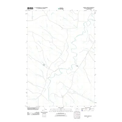
2011 Map of Hawkey Creek
USGS Topo · Published 2011About this map
The Powder River carves a winding path through this corner of southeast Montana, serving as the central hydrological feature of the landscape. Feeding into this significant waterway is a dense network of seasonal drainages, including Hawkey Creek, Wolf Creek, and Deer Creek. The terrain is defined by its drainage basins and landforms like Poker Jim Gulch, reflecting a traditional ranching environment where water management is critical. Evidence of such infrastructure is seen at Watters Number 1 Dam on Gring Creek, illustrating how local land owners modified the drainage of Magpie Creek and Wild Cat Creek for livestock and agricultural use. A sparse network of gravel roads, such as Powderville West Rd and Powderville East Rd, provides the primary access through this open country, connecting isolated points along the river valley and the banks of Pilgrim Creek.
Find a feature on this map
20 named features on this map. Tap any name to fly to it.
Don’t see what you’re looking for? This feature index may not catch every label — zoom into the map to look around manually.
Map Details
Editions of this 2011 Hawkey Creek Map
This is the sole edition of this map. No revisions or reprints were ever made.
Other maps of this area

1954 · Ekalaka
USGS Topo · 1:250,000

1956 · Ekalaka
USGS Topo · 1:250,000

1958 · Ekalaka
USGS Topo · 1:250,000

1965 · Ekalaka
USGS Topo · 1:250,000

1973 · Cross S School
USGS Topo · 1:24,000

1973 · Monday Creek
USGS Topo · 1:24,000

1973 · Moonlight Creek
USGS Topo · 1:24,000

1973 · Hawkey Creek
USGS Topo · 1:24,000
1973 · Broadus
USGS Topo · 1:24,000
1973 · Johnnie Creek
USGS Topo · 1:24,000