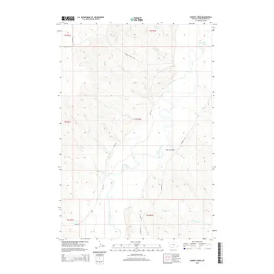
2014 Map of Hawkey Creek
USGS Topo · Published 2014About this map
The Powder River meanders through this landscape of high plains and drainages in Montana's ranching country. The terrain is defined by a dense network of seasonal and perennial waterways, where the central river valley is fed by Wolf Cr, Magpie Cr, and Wild Cat Cr. This topographic study reveals the intricate drainage patterns that have shaped the land, notably within Poker Jim Gulch and along the eastern reaches of Poker Jim Cr.
Find a feature on this map
28 named features on this map. Tap any name to fly to it.
Don’t see what you’re looking for? This feature index may not catch every label — zoom into the map to look around manually.
Map Details
Editions of this 2014 Hawkey Creek Map
This is the sole edition of this map. No revisions or reprints were ever made.
Other maps of this area

1954 · Ekalaka
USGS Topo · 1:250,000

1956 · Ekalaka
USGS Topo · 1:250,000

1958 · Ekalaka
USGS Topo · 1:250,000

1965 · Ekalaka
USGS Topo · 1:250,000

1973 · Cross S School
USGS Topo · 1:24,000

1973 · Monday Creek
USGS Topo · 1:24,000

1973 · Moonlight Creek
USGS Topo · 1:24,000

1973 · Hawkey Creek
USGS Topo · 1:24,000
1973 · Broadus
USGS Topo · 1:24,000
1973 · Johnnie Creek
USGS Topo · 1:24,000