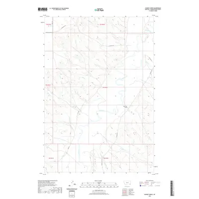
2020 Map of Hawkey Creek
USGS Topo · Published 2020About this map
The Powder River meanders through the heart of this corner of Powder River County, Montana, carving a complex drainage system across the high plains. The landscape is defined by the deep dissection of Poker Jim Gulch and the numerous seasonal watercourses that feed into the main river valley. Tributaries like Hawkey Cr and Rough Cr provide natural landmarks in this rural ranching country, where the township and range system remains the primary method of land organization.
Find a feature on this map
30 named features on this map. Tap any name to fly to it.
Don’t see what you’re looking for? This feature index may not catch every label — zoom into the map to look around manually.
Map Details
Editions of this 2020 Hawkey Creek Map
This is the sole edition of this map. No revisions or reprints were ever made.
Other maps of this area

1954 · Ekalaka
USGS Topo · 1:250,000

1956 · Ekalaka
USGS Topo · 1:250,000

1958 · Ekalaka
USGS Topo · 1:250,000

1965 · Ekalaka
USGS Topo · 1:250,000

1973 · Cross S School
USGS Topo · 1:24,000

1973 · Monday Creek
USGS Topo · 1:24,000

1973 · Moonlight Creek
USGS Topo · 1:24,000

1973 · Hawkey Creek
USGS Topo · 1:24,000
1973 · Broadus
USGS Topo · 1:24,000
1973 · Johnnie Creek
USGS Topo · 1:24,000