1977 Map of Hawkinsville
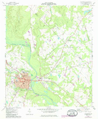
USGS Topo · Published 1977This historical map portrays the area of Hawkinsville in 1977, primarily covering Pulaski County as well as portions of Laurens County, Telfair County, Bleckley County, Macon County, Dooly County, Houston County, Sumter County, Peach County, Wilcox County, Twiggs County, Crisp County, and Dodge County. Featuring a scale of 1:100000, this map provides a highly detailed snapshot of the terrain, roads, buildings, counties, and historical landmarks in the Hawkinsville region at the time. Published in 1977, it is the sole known edition of this map.
Find a feature on this map
72 named features on this map. Tap any name to fly to it.
Don’t see what you’re looking for? This feature index may not catch every label — zoom into the map to look around manually.
Map Details
Editions of this 1977 Hawkinsville Map
This is the sole edition of this map. No revisions or reprints were ever made.
Historical Maps of Alligood Through Time
3 maps found