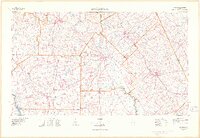
1977 Map of Hawkinsville
USGS Topo · Published 1977About this map
Hawkinsville serves as the central hub of this South Georgia landscape, where the meandering Ocmulgee River snakes southward toward Abbeville. The region's mid-century economic structure is defined by a dense lattice of rail lines, including the Central of Georgia, Southern, and Seaboard Coast Line, which connect agricultural centers like Vienna, Cochran, and Eastman. A notable military presence is recorded at the U S Naval Reservation just north of the Ocmulgee, while Middle Georgia College highlights the educational footprint in Cochran.
Find a feature on this map
72 named features on this map. Tap any name to fly to it.
Don’t see what you’re looking for? This feature index may not catch every label — zoom into the map to look around manually.
Map Details
Editions of this 1977 Hawkinsville Map
This is the sole edition of this map. No revisions or reprints were ever made.
Other maps of this area

1953 · Dothan
USGS Topo · 1:250,000

1953 · Waycross
USGS Topo · 1:250,000

1954 · Dothan
USGS Topo · 1:250,000

1955 · Dothan
USGS Topo · 1:250,000

1955 · Phenix City
USGS Topo · 1:250,000

1956 · Fort Valley
USGS Topo · 1:62,500

1956 · Cochran
USGS Topo · 1:62,500

1956 · Perry
USGS Topo · 1:62,500

1956 · Warner Robins
USGS Topo · 1:62,500

1956 · Jeffersonville
USGS Topo · 1:62,500