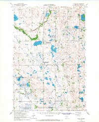
1966 Map of Hawley SE
USGS Topo · Published 1967About this map
The Buffalo River snakes through the glacial landscape of Clay County in the mid-1960s, a terrain defined by dozens of small lakes and extensive conservation efforts. The map reveals a high density of state-managed lands, including the Hawley State Wildlife Management Area and the Bjornson State Wildlife Management Area. Local history is anchored by sites like the Silver Lake Pioneer Cem and the Hegland Ch, while the Northern Pacific railroad cuts a diagonal path across the northern sections near the Hawley corporate boundary. This survey captures a moment when the regional economy balanced the legacy of early settlement with modern infrastructure, such as the Sewage Disposal Ponds and various Gravel Pits that punctuate the prairie.
Find a feature on this map
33 named features on this map. Tap any name to fly to it.
Don’t see what you’re looking for? This feature index may not catch every label — zoom into the map to look around manually.
Map Details
Editions of this 1966 Hawley SE Map
This is the sole edition of this map. No revisions or reprints were ever made.
Other maps of this area

1914 · Pelican Rapids
USGS Topo · 1:62,500

1917 · Pelican Rapids
USGS Topo · 1:62,500

1919 · Barnesville
USGS Topo · 1:62,500

1919 · Hawley
USGS Topo · 1:62,500

1952 · Barnesville
USGS Topo · 1:62,500

1953 · Fargo
USGS Topo · 1:250,000

1956 · Fargo
USGS Topo · 1:250,000
1966 · Hawley NW
USGS Topo · 1:24,000
1966 · Dale
USGS Topo · 1:24,000
1966 · Hawley
USGS Topo · 1:24,000