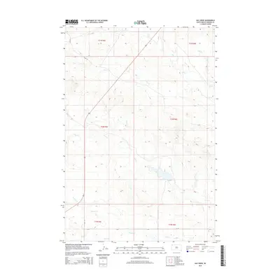
2015 Map of Hay Creek
USGS Topo · Published 2015About this map
Hydrological patterns define this corner of Harding County, where a network of ephemeral drainages carves through the high plains. The landscape is structured by the southward flow of Hay Cr and the eastern reach of Bull Cr, which provide the primary topographic relief in an area otherwise dominated by open range. This 2015 survey illustrates a sparsely populated region primarily managed through the Public Land Survey System, as evidenced by the clear township and range boundaries like t21n r5e and t20n r6e. Infrastructure is limited to essential rural connectors such as S Cave Rd and E6 Rd, which traverse the wide valleys of Boxelder Cr and Jones Cr. The map captures a moment in the modern era of the Dakotas where land use remains centered on the natural drainage basins of the Missouri River watershed, including the remote headwaters of Sheep Cr.
Find a feature on this map
15 named features on this map. Tap any name to fly to it.
Don’t see what you’re looking for? This feature index may not catch every label — zoom into the map to look around manually.
Map Details
Editions of this 2015 Hay Creek Map
This is the sole edition of this map. No revisions or reprints were ever made.
Other maps of this area

1935 · Reva
USGS Topo · 1:125,000

1935 · Buffalo
USGS Topo · 1:125,000

1954 · Lemmon
USGS Topo · 1:250,000

1957 · Lemmon
USGS Topo · 1:250,000

1968 · Ludlow
USGS Topo · 1:24,000

1968 · Ludlow SE
USGS Topo · 1:24,000

1969 · Ladner SE
USGS Topo · 1:24,000

1971 · Buffalo
USGS Topo · 1:24,000
1971 · Sheep Pen Draw
USGS Topo · 1:24,000

1971 · McKenzie Butte
USGS Topo · 1:24,000