
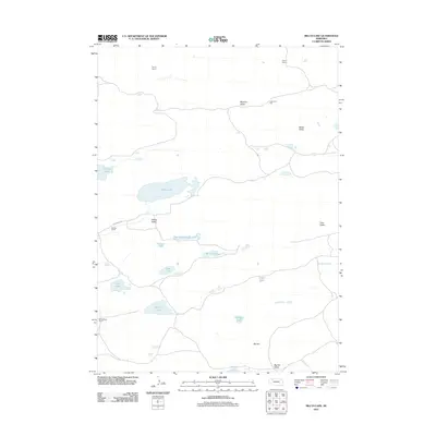
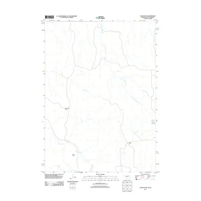
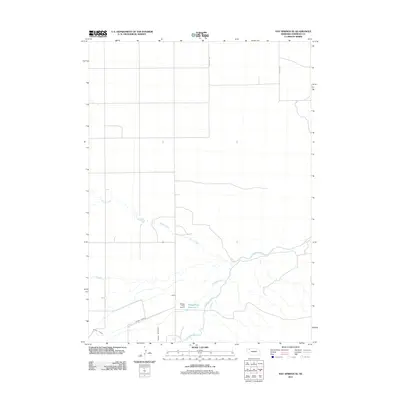
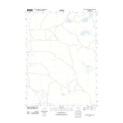
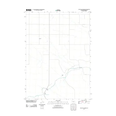
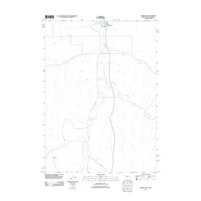
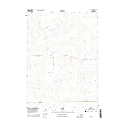
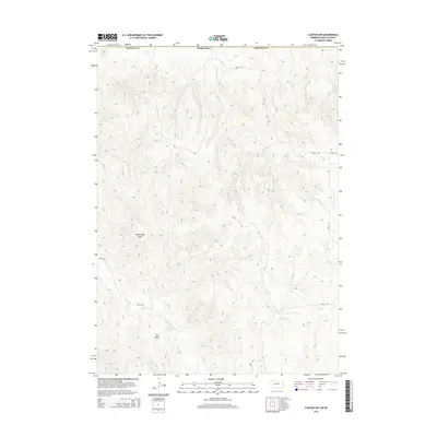
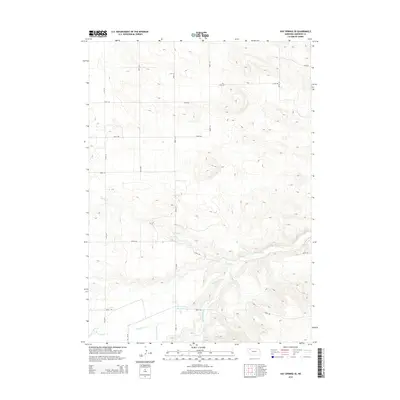
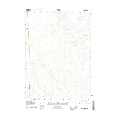
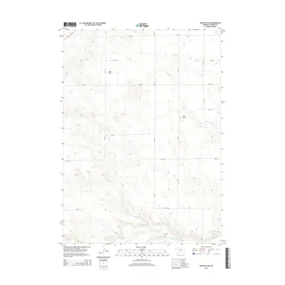
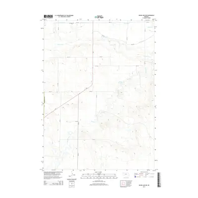
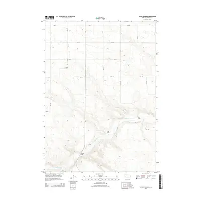
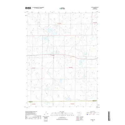
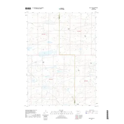
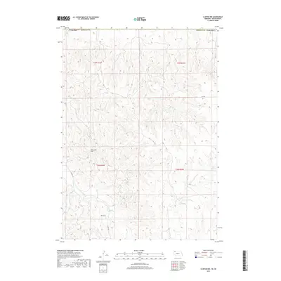
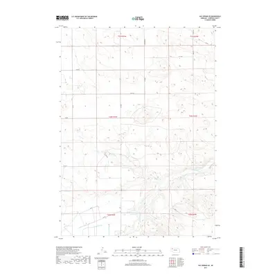
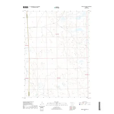
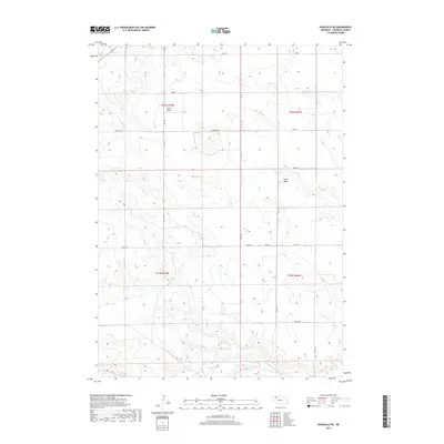
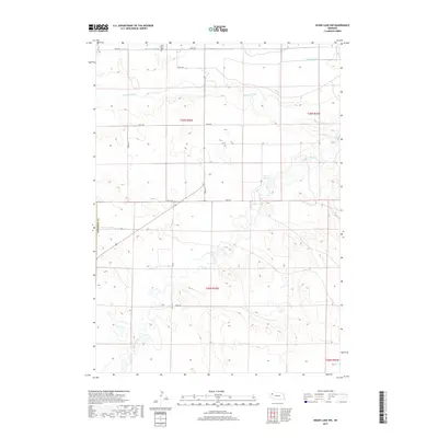
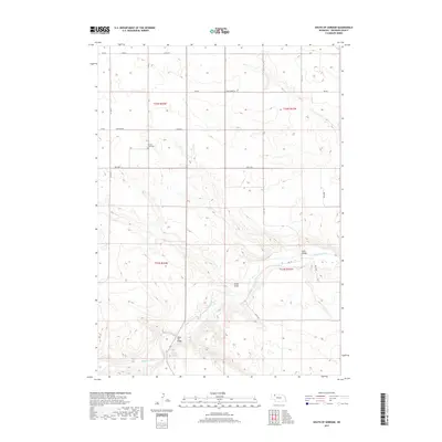
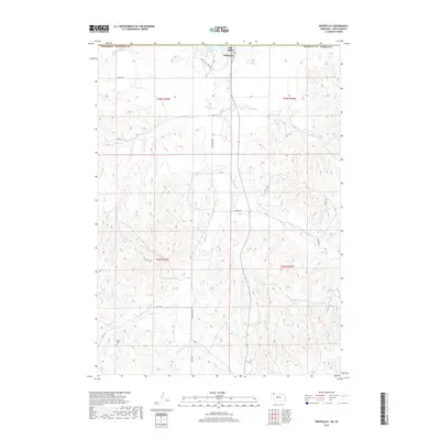
1960 Map of Hay Springs SW
USGS Topo · Published 1961About this map
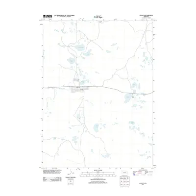
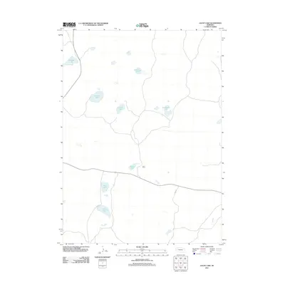
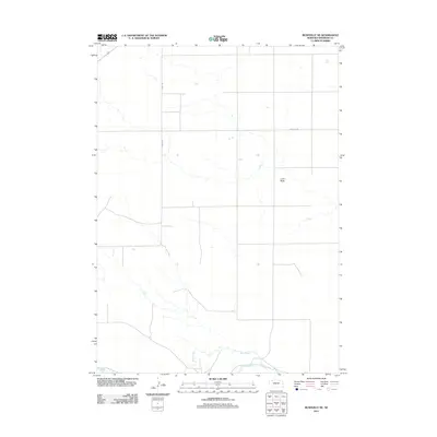
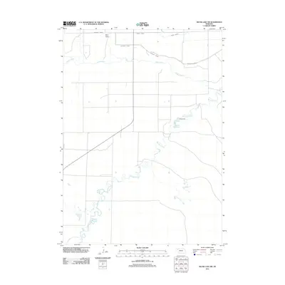
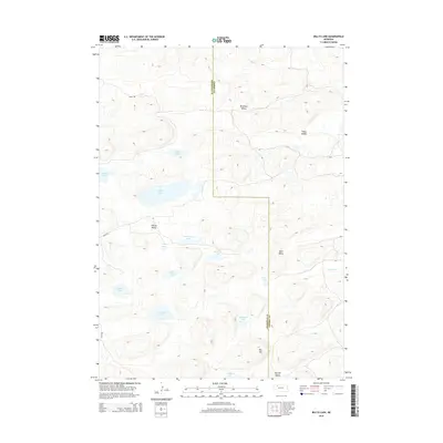
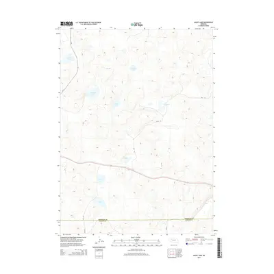
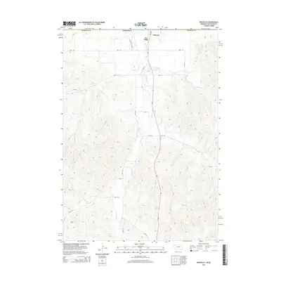
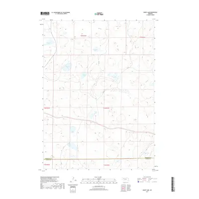
Agricultural development and irrigation infrastructure define the landscape of Sheridan County on this 1960s survey. The map centers on the extensive Mirage Flats, including the West Mirage Flats and East Mirage Flats, where the Mirage Flats Canal winds through the terrain. The presence of the Mirage Flats Project Headquarters underscores the importance of water management in this portion of the Missouri River Basin during the mid-20th century. Local social centers are visible in the placement of the New Hope Ch and St Peters Ch, alongside rural education sites like Sandridge Sch and Alcove Sch. Technical details of the irrigation system, such as a Siphon and Flume, illustrate the engineered nature of the plains during this era of agrarian growth.
Find a feature on this map
15 named features on this map. Tap any name to fly to it.
Don’t see what you’re looking for? This feature index may not catch every label — zoom into the map to look around manually.
Map Details
Editions of this 1960 Hay Springs SW Map
This is the sole edition of this map. No revisions or reprints were ever made.
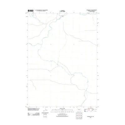
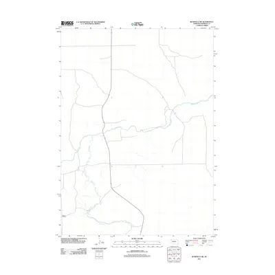
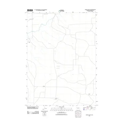
Historical Maps of Sheridan County Through Time
211 maps found

1948 Antioch
Sheridan County, NE

1948 Bingham
Sheridan County, NE

1948 Lakeside
Sheridan County, NE

1948 Spade Ranch
Sheridan County, NE

1948 Twin Lakes
Sheridan County, NE

1949 Antioch
Sheridan County, NE

1950 Bingham
Sheridan County, NE

1950 Lakeside
Sheridan County, NE

1950 Skunk Lake
Sheridan County, NE

1950 Spade Ranch
Sheridan County, NE

1950 Twin Lakes
Sheridan County, NE

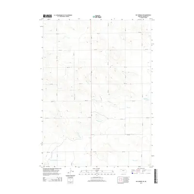
1960 Hay Springs SE
Sheridan County, NE
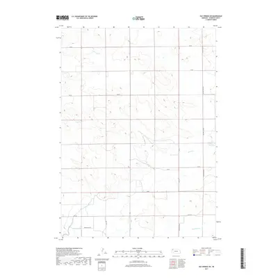
1960 Hay Springs SW
Sheridan County, NE

1966 Hay Springs NE
Sheridan County, NE

1966 Rushville SW
Sheridan County, NE

1969 Beaver Wall
Sheridan County, NE

1969 Bovee Valley West
Sheridan County, NE

1969 Clinton NE
Sheridan County, NE

1969 Clinton NW
Sheridan County, NE

1969 Clinton SW
Sheridan County, NE

1969 Gordon NW
Sheridan County, NE

1969 Rushville NE
Sheridan County, NE

1969 Rushville SE
Sheridan County, NE

1969 South Of Gordon
Sheridan County, NE

1969 Whiteclay SE
Sheridan County, NE

1969 Whiteclay
Sheridan County, NE

1969 Whiteclay SW
Sheridan County, NE

1989 Antioch
Sheridan County, NE

1989 Argo Hill
Sheridan County, NE

1989 Arnold Lake
Sheridan County, NE

1989 Billys Lake
Sheridan County, NE

1989 Bingham
Sheridan County, NE

1989 Dolly Warden Lake
Sheridan County, NE

1989 Ellsworth
Sheridan County, NE

1989 Gaunt Lake
Sheridan County, NE

1989 Green Lake
Sheridan County, NE

1989 Jesse Lke
Sheridan County, NE

1989 Krause Lake East
Sheridan County, NE

1989 Krause Lake West
Sheridan County, NE

1989 Lakeside
Sheridan County, NE

1989 Lowe Valley
Sheridan County, NE

1989 Peter Long Lake
Sheridan County, NE

1989 Skunk Lake NE
Sheridan County, NE

1989 Skunk Lake NW
Sheridan County, NE

1989 Skunk Lake
Sheridan County, NE

1989 Skunk Lake SW
Sheridan County, NE

1989 Smith Lake
Sheridan County, NE

1989 Twin Lakes NE
Sheridan County, NE

1989 Twin Lakes
Sheridan County, NE

1989 White Lake
Sheridan County, NE

1989 Wolford Valley
Sheridan County, NE
2011 Antioch
Sheridan County, NE
2011 Argo Hill
Sheridan County, NE
2011 Arnold Lake
Sheridan County, NE
2011 Beaver Wall
Sheridan County, NE
2011 Billys Lake
Sheridan County, NE
2011 Bingham
Sheridan County, NE
2011 Bovee Valley West
Sheridan County, NE
2011 Clinton NE
Sheridan County, NE
2011 Clinton NW
Sheridan County, NE
2011 Clinton SW
Sheridan County, NE
2011 Dolly Warden Lake
Sheridan County, NE
2011 Ellsworth
Sheridan County, NE
2011 Gaunt Lake
Sheridan County, NE
2011 Gordon NW
Sheridan County, NE
2011 Green Lake
Sheridan County, NE
2011 Hay Springs NE
Sheridan County, NE
2011 Hay Springs SE
Sheridan County, NE
2011 Hay Springs SW
Sheridan County, NE
2011 Jesse Lake
Sheridan County, NE
2011 Krause Lake East
Sheridan County, NE
2011 Krause Lake West
Sheridan County, NE
2011 Lakeside
Sheridan County, NE
2011 Lowe Valley
Sheridan County, NE
2011 Peter Long Lake
Sheridan County, NE
2011 Rushville NE
Sheridan County, NE
2011 Rushville SE
Sheridan County, NE
2011 Rushville SW
Sheridan County, NE
2011 Skunk Lake NE
Sheridan County, NE
2011 Skunk Lake NW
Sheridan County, NE
2011 Skunk Lake
Sheridan County, NE
2011 Skunk Lake SW
Sheridan County, NE
2011 Smith Lake
Sheridan County, NE
2011 South of Gordon
Sheridan County, NE
2011 Twin Lakes NE
Sheridan County, NE
2011 Twin Lakes
Sheridan County, NE
2011 Whiteclay SE
Sheridan County, NE
2011 Whiteclay
Sheridan County, NE
2011 Whiteclay SW
Sheridan County, NE
2011 White Lake
Sheridan County, NE
2011 Wolford Valley
Sheridan County, NE
2014 Antioch
Sheridan County, NE
2014 Argo Hill
Sheridan County, NE
2014 Arnold Lake
Sheridan County, NE
2014 Beaver Wall
Sheridan County, NE
2014 Billys Lake
Sheridan County, NE
2014 Bingham
Sheridan County, NE
2014 Bovee Valley West
Sheridan County, NE
2014 Clinton NE
Sheridan County, NE
2014 Clinton NW
Sheridan County, NE
2014 Clinton SW
Sheridan County, NE
2014 Dolly Warden Lake
Sheridan County, NE
2014 Ellsworth
Sheridan County, NE
2014 Gaunt Lake
Sheridan County, NE
2014 Gordon NW
Sheridan County, NE
2014 Green Lake
Sheridan County, NE
2014 Hay Springs NE
Sheridan County, NE
2014 Hay Springs SE
Sheridan County, NE
2014 Hay Springs SW
Sheridan County, NE
2014 Jesse Lake
Sheridan County, NE
2014 Krause Lake East
Sheridan County, NE
2014 Krause Lake West
Sheridan County, NE
2014 Lakeside
Sheridan County, NE
2014 Lowe Valley
Sheridan County, NE
2014 Peter Long Lake
Sheridan County, NE
2014 Rushville NE
Sheridan County, NE
2014 Rushville SE
Sheridan County, NE
2014 Rushville SW
Sheridan County, NE
2014 Skunk Lake NE
Sheridan County, NE
2014 Skunk Lake NW
Sheridan County, NE
2014 Skunk Lake
Sheridan County, NE
2014 Skunk Lake SW
Sheridan County, NE
2014 Smith Lake
Sheridan County, NE
2014 South of Gordon
Sheridan County, NE
2014 Twin Lakes NE
Sheridan County, NE
2014 Twin Lakes
Sheridan County, NE
2014 Whiteclay SE
Sheridan County, NE
2014 Whiteclay
Sheridan County, NE
2014 Whiteclay SW
Sheridan County, NE
2014 White Lake
Sheridan County, NE
2014 Wolford Valley
Sheridan County, NE
2017 Antioch
Sheridan County, NE
2017 Argo Hill
Sheridan County, NE
2017 Arnold Lake
Sheridan County, NE
2017 Beaver Wall
Sheridan County, NE
2017 Billys Lake
Sheridan County, NE
2017 Bingham
Sheridan County, NE
2017 Bovee Valley West
Sheridan County, NE
2017 Clinton NE
Sheridan County, NE
2017 Clinton NW
Sheridan County, NE
2017 Clinton SW
Sheridan County, NE
2017 Dolly Warden Lake
Sheridan County, NE
2017 Ellsworth
Sheridan County, NE
2017 Gaunt Lake
Sheridan County, NE
2017 Gordon NW
Sheridan County, NE
2017 Green Lake
Sheridan County, NE
2017 Hay Springs NE
Sheridan County, NE
2017 Hay Springs SE
Sheridan County, NE
2017 Hay Springs SW
Sheridan County, NE
2017 Jesse Lake
Sheridan County, NE
2017 Krause Lake East
Sheridan County, NE
2017 Krause Lake West
Sheridan County, NE
2017 Lakeside
Sheridan County, NE
2017 Lowe Valley
Sheridan County, NE
2017 Peter Long Lake
Sheridan County, NE
2017 Rushville NE
Sheridan County, NE
2017 Rushville SE
Sheridan County, NE
2017 Rushville SW
Sheridan County, NE
2017 Skunk Lake NE
Sheridan County, NE
2017 Skunk Lake NW
Sheridan County, NE
2017 Skunk Lake
Sheridan County, NE
2017 Skunk Lake SW
Sheridan County, NE
2017 Smith Lake
Sheridan County, NE
2017 South of Gordon
Sheridan County, NE
2017 Twin Lakes NE
Sheridan County, NE
2017 Twin Lakes
Sheridan County, NE
2017 Whiteclay SE
Sheridan County, NE
2017 Whiteclay
Sheridan County, NE
2017 Whiteclay SW
Sheridan County, NE
2017 White Lake
Sheridan County, NE
2017 Wolford Valley
Sheridan County, NE

2021 Antioch
Sheridan County, NE

2021 Argo Hill
Sheridan County, NE

2021 Arnold Lake
Sheridan County, NE

2021 Beaver Wall
Sheridan County, NE

2021 Billys Lake
Sheridan County, NE

2021 Bingham
Sheridan County, NE

2021 Bovee Valley West
Sheridan County, NE

2021 Clinton NE
Sheridan County, NE

2021 Clinton NW
Sheridan County, NE

2021 Clinton SW
Sheridan County, NE

2021 Dolly Warden Lake
Sheridan County, NE

2021 Ellsworth
Sheridan County, NE

2021 Gaunt Lake
Sheridan County, NE

2021 Gordon NW
Sheridan County, NE

2021 Green Lake
Sheridan County, NE

2021 Hay Springs NE
Sheridan County, NE

2021 Hay Springs SE
Sheridan County, NE

2021 Hay Springs SW
Sheridan County, NE

2021 Jesse Lake
Sheridan County, NE

2021 Krause Lake East
Sheridan County, NE

2021 Krause Lake West
Sheridan County, NE

2021 Lakeside
Sheridan County, NE

2021 Lowe Valley
Sheridan County, NE

2021 Peter Long Lake
Sheridan County, NE

2021 Rushville NE
Sheridan County, NE

2021 Rushville SE
Sheridan County, NE

2021 Rushville SW
Sheridan County, NE

2021 Skunk Lake NE
Sheridan County, NE

2021 Skunk Lake NW
Sheridan County, NE

2021 Skunk Lake
Sheridan County, NE

2021 Skunk Lake SW
Sheridan County, NE

2021 Smith Lake
Sheridan County, NE

2021 South of Gordon
Sheridan County, NE

2021 Twin Lakes NE
Sheridan County, NE

2021 Twin Lakes
Sheridan County, NE

2021 Whiteclay SE
Sheridan County, NE

2021 Whiteclay
Sheridan County, NE

2021 Whiteclay SW
Sheridan County, NE

2021 White Lake
Sheridan County, NE

2021 Wolford Valley
Sheridan County, NE