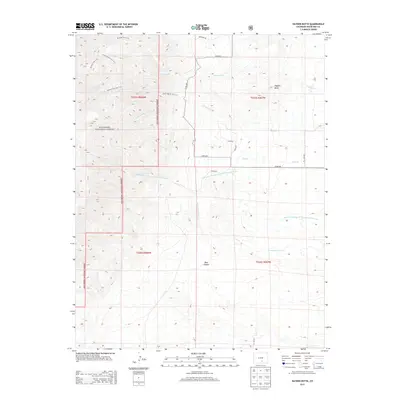
2013 Map of Hayden Butte
USGS Topo · Published 2013About this map
San Isabel National Forest dominates the western half of this landscape, where the terrain transitions from high woodland ridges down into the expansive drainage basins of the high plains. A network of high-elevation paths, including the Bartlett Trail 1310, South Apache Trail 1311, and Apache Falls Trail 1357, provides a look at how this corner of Colorado was navigated before the modern road system. The water drainage pattern is particularly striking, showing the complex branching of Apache Creek and its many tributaries like Chitwood Br S Apache Cr, which feed into various arroyos. On the eastern side, the presence of Hayden Butte and Pole Canyon suggests the sharp geological relief typical of the Huerfano County area. This survey also records the detailed local road network, such as Co RD-650 and Co RD-671, which connect the scattered agricultural and ranching properties in the lower elevations.
Find a feature on this map
27 named features on this map. Tap any name to fly to it.
Don’t see what you’re looking for? This feature index may not catch every label — zoom into the map to look around manually.
Map Details
Editions of this 2013 Hayden Butte Map
This is the sole edition of this map. No revisions or reprints were ever made.
Other maps of this area

1889 · Huerfano Park
USGS Topo · 1:125,000

1891 · Walsenburg
USGS Topo · 1:125,000

1892 · Huerfano Park
USGS Topo · 1:125,000

1894 · Walsenburg
USGS Topo · 1:125,000

1897 · Walsenburg
USGS Topo · 1:125,000

1900 · Walsenburg
USGS Topo · 1:125,000

1954 · Trinidad
USGS Topo · 1:250,000

1955 · Trinidad
USGS Topo · 1:250,000

1958 · Trinidad
USGS Topo · 1:250,000

1959 · Trinidad
USGS Topo · 1:250,000