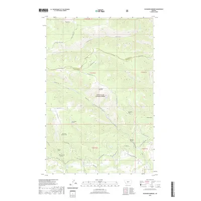
2020 Map of Haymaker Narrows
USGS Topo · Published 2020About this map
The Little Belt Mountains dominate this landscape on the border of Judith Basin and Wheatland counties, where the high-altitude terrain is defined by complex coulees and seasonal water sources. The Lewis & Clark National Forest encompasses much of the area, featuring distinctive landmarks such as Elephant Rock and the sharp rise of Bartleson Peak. A network of historic paths and backcountry routes, including the Haymaker Trail and Mt High Jeep, cross the mountain slopes to reach isolated water points like Sixshooter Spring and Trombone Spring. The geography is particularly intricate near the Haymaker Narrows and the Morrisy Coulee Narrows, where drainage systems like E Fork Haymaker Cr have carved deep passages through the limestone. Evidence of past wildfires is marked at Bluff Mtn Burn, while more permanent landscape features like Iron Springs Coulee provide reliable reference points for those navigating this high country.
Find a feature on this map
37 named features on this map. Tap any name to fly to it.
Don’t see what you’re looking for? This feature index may not catch every label — zoom into the map to look around manually.
Map Details
Editions of this 2020 Haymaker Narrows Map
This is the sole edition of this map. No revisions or reprints were ever made.
Other maps of this area

1886 · Little Belt Mts.
USGS Topo · 1:250,000

1894 · Little Belt Mts.
USGS Topo · 1:250,000

1897 · Little Belt Mts.
USGS Topo · 1:250,000

1898 · Little Belt Mts.
USGS Topo · 1:250,000

1902 · Little Belt Mts.
USGS Topo · 1:250,000

1948 · White Sulphur Springs
USGS Topo · 1:250,000

1958 · White Sulphur Springs
USGS Topo · 1:250,000

1961 · White Sulphur Springs
USGS Topo · 1:250,000

1965 · White Sulphur Springs
USGS Topo · 1:250,000
1970 · Browns Canyon
USGS Topo · 1:24,000