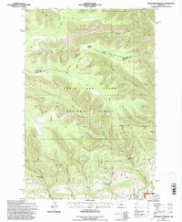
1995 Map of Haymaker Narrows
USGS Topo · Published 1997About this map
The Little Belt Mountains define the high country where Judith Basin and Wheatland counties meet within the Lewis and Clark National Forest. This mid-1990s revision by the U.S. Forest Service captures a landscape of extreme vertical relief, characterized by the dramatic Haymaker Narrows and the Morris Coulee Narrows. Significant summits like Bartleson Peak and unique formations such as Elephant Rock anchor the geography.
Find a feature on this map
21 named features on this map. Tap any name to fly to it.
Don’t see what you’re looking for? This feature index may not catch every label — zoom into the map to look around manually.
Map Details
Editions of this 1995 Haymaker Narrows Map
This is the sole edition of this map. No revisions or reprints were ever made.
Other maps of this area

1886 · Little Belt Mts.
USGS Topo · 1:250,000

1894 · Little Belt Mts.
USGS Topo · 1:250,000

1897 · Little Belt Mts.
USGS Topo · 1:250,000

1898 · Little Belt Mts.
USGS Topo · 1:250,000

1902 · Little Belt Mts.
USGS Topo · 1:250,000

1948 · White Sulphur Springs
USGS Topo · 1:250,000

1958 · White Sulphur Springs
USGS Topo · 1:250,000

1961 · White Sulphur Springs
USGS Topo · 1:250,000

1965 · White Sulphur Springs
USGS Topo · 1:250,000
1970 · Browns Canyon
USGS Topo · 1:24,000