1983 Map of Haynes SE
USGS Topo · Published 1984About this map
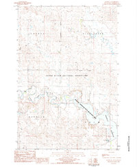
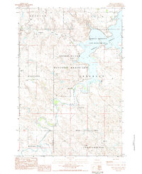
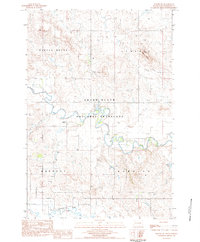
The North Fork Grand River meanders across this Perkins County landscape, feeding into the upper reaches of the Shadehill Reservoir. The map illustrates a transitional environment where the managed lands of the Grand River National Grassland meet the public access points of the Shadehill Reservoir State Recreation Area. This region is characterized by sparse development, with various Well sites and a Spring indicating the critical importance of water resources in the high plains. Navigation and utility are marked by practical landmarks such as a Gaging Sta along the river and a Boat Ramp on the reservoir's edge. The terrain is organized into large named sections like Liberty, Burdick, and Seim, while Flat Creek flows through the northern reaches, defining the local drainage patterns as they existed in the early 1980s.
Find a feature on this map
15 named features on this map. Tap any name to fly to it.
Don’t see what you’re looking for? This feature index may not catch every label — zoom into the map to look around manually.
Map Details
Editions of this 1983 Haynes SE Map
This is the sole edition of this map. No revisions or reprints were ever made.
Other maps of this area

1954 · Lemmon
USGS Topo · 1:250,000

1957 · Lemmon
USGS Topo · 1:250,000
1974 · White Butte
USGS Topo · 1:24,000
1974 · Lemmon
USGS Topo · 1:24,000
1974 · Haynes
USGS Topo · 1:24,000
1983 · Bison NE
USGS Topo · 1:24,000
1983 · Meadow NW
USGS Topo · 1:24,000
1983 · Bison NW
USGS Topo · 1:24,000
1983 · Sommerville
USGS Topo · 1:24,000
1983 · Haynes SW
USGS Topo · 1:24,000