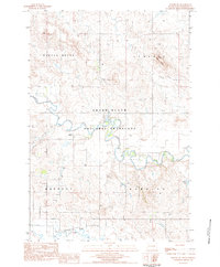
1983 Map of Haynes SW
USGS Topo · Published 1984About this map
The Grand River National Grassland dominates this Perkins County landscape, where the North Fork Grand River joins the main branch of the Grand River. This 1983 survey illustrates a sparsely populated region of western South Dakota defined by its drainage basins and isolated landmarks. Large topographic rises like Castle Butte and White Butte provide clear orientation points above the winding river valleys. Human activity is marked primarily by ranching and resource management, evidenced by numerous water wells and the Johnson Dam in the east. The confluence of the river forks and the presence of Lodgepole Creek highlight the critical role of water in this semi-arid terrain, while the solitary Gravel Pit near the river suggests the modest industrial footprint of the early 1980s.
Find a feature on this map
14 named features on this map. Tap any name to fly to it.
Don’t see what you’re looking for? This feature index may not catch every label — zoom into the map to look around manually.
Map Details
Editions of this 1983 Haynes SW Map
This is the sole edition of this map. No revisions or reprints were ever made.
Other maps of this area

1954 · Lemmon
USGS Topo · 1:250,000

1957 · Lemmon
USGS Topo · 1:250,000

1974 · White Butte
USGS Topo · 1:24,000

1974 · Kid Rich Butte
USGS Topo · 1:24,000

1974 · Haynes
USGS Topo · 1:24,000

1983 · Lodgepole SE
USGS Topo · 1:24,000

1983 · Haynes SE
USGS Topo · 1:24,000

1983 · Bison NE
USGS Topo · 1:24,000

1983 · Cole Dam
USGS Topo · 1:24,000

1983 · Bison NW
USGS Topo · 1:24,000