
1974 Map of Kid Rich Butte
USGS Topo · Published 1978About this map
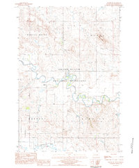
Kid Rich Butte and the surrounding high plains of the North Dakota and South Dakota border region appear here in the mid-1970s. The landscape is defined by the winding course of the North Fork Grand River and the larger Grand River, which cut through the open terrain of Scott and Hettinger. Transportation and utility infrastructure are concentrated in the northern portion of the map, where the Chicago Milwaukee St Paul and Pacific railroad runs parallel to a series of sewage disposal ponds and a local pumping station. Elevated landmarks like Castle Butte and Big Butte provide distinct navigational points across the otherwise steady elevation of the flat country. Cultural development is sparse, represented primarily by the Hettinger Country Club and various scattered wells, indicating a region largely dedicated to ranching or resource extraction during this era.
Find a feature on this map
17 named features on this map. Tap any name to fly to it.
Don’t see what you’re looking for? This feature index may not catch every label — zoom into the map to look around manually.
Map Details
Editions of this 1974 Kid Rich Butte Map
This is the sole edition of this map. No revisions or reprints were ever made.
Other maps of this area

1953 · Dickinson
USGS Topo · 1:250,000

1954 · Lemmon
USGS Topo · 1:250,000

1957 · Dickinson
USGS Topo · 1:250,000

1957 · Lemmon
USGS Topo · 1:250,000

1974 · Hettinger North
USGS Topo · 1:24,000

1974 · Hettinger South
USGS Topo · 1:24,000

1974 · Haynes
USGS Topo · 1:24,000

1980 · Mott
USGS Topo · 1:100,000

1983 · Lodgepole SE
USGS Topo · 1:24,000
1983 · Haynes SW
USGS Topo · 1:24,000