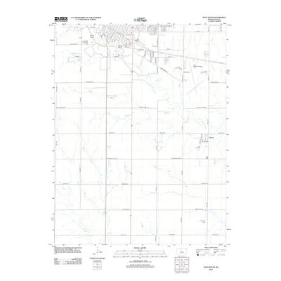
2012 Map of Hays South
USGS Topo · Published 2012About this map
Ft Hays State Univ anchors the northern portion of this landscape, marking the transition from the collegiate and residential districts of the city to the surrounding agricultural plains of Ellis County. The geography is defined by the winding course of Big Cr and its tributary, Chetolah Cr, which cut through the grid of section lines and rural roads. To the southeast, the small settlement of Munjor remains a distinct community cluster, centered near Saint Francis Cem. Infrastructure for transportation and leisure is prominent, ranging from the Hays Municipal Airport and the Fort Hays Municipal Golf Course to local landmarks like Stecklein Field. The map illustrates a well-developed network of local thoroughfares such as Us-40 BYP and Military Rd that connect the urban core to the outlining farmsteads and historic burial grounds like Ft Cem.
Find a feature on this map
62 named features on this map. Tap any name to fly to it.
Don’t see what you’re looking for? This feature index may not catch every label — zoom into the map to look around manually.
Map Details
Editions of this 2012 Hays South Map
This is the sole edition of this map. No revisions or reprints were ever made.
Other maps of this area

1896 · Hays
USGS Topo · 1:125,000

1955 · Great Bend
USGS Topo · 1:250,000

1957 · Great Bend
USGS Topo · 1:250,000

1958 · Great Bend
USGS Topo · 1:250,000

1961 · Yocemento
USGS Topo · 1:24,000

1961 · Hays South
USGS Topo · 1:24,000

1961 · Catharine
USGS Topo · 1:24,000
1961 · Hays North
USGS Topo · 1:24,000

1961 · Antonino
USGS Topo · 1:24,000

1961 · Victoria
USGS Topo · 1:24,000