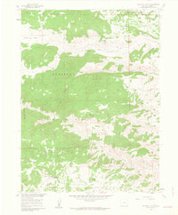
1960 Map of Haystack Gulch
USGS Topo · Published 1962About this map
Roosevelt National Forest dominates this mountain landscape, where the complex drainage systems of Rabbit Creek and its North, Middle, and South Forks converge. The terrain is defined by rugged landmarks like Sheep Mountain and Blacktail Point, with deep cuts through the topography including Teakettle Canyon and Hole Canyon. Settled activity in this high-altitude area is concentrated near the Red Feather Lakes Road, where the community of Log Cabin and the Lone Pine Sch represent the local centers of social and civic life during the early 1960s. The presence of numerous named springs and grazing areas like Bull Garden and the Prairie Divide suggests a landscape utilized for ranching and timber, while the distinct profile of Haystack Butte and the winding course of Lone Pine Creek anchor the southern portion of the survey.
Find a feature on this map
21 named features on this map. Tap any name to fly to it.
Don’t see what you’re looking for? This feature index may not catch every label — zoom into the map to look around manually.
Map Details
Editions of this 1960 Haystack Gulch Map
4 editions found
Other maps of this area

1907 · Livermore
USGS Topo · 1:125,000

1909 · Livermore
USGS Topo · 1:125,000

1916 · Home
USGS Topo · 1:125,000

1920 · Home
USGS Topo · 1:125,000

1954 · Greeley
USGS Topo · 1:250,000

1957 · Greeley
USGS Topo · 1:250,000

1958 · Greeley
USGS Topo · 1:250,000

1960 · Haystack Gulch
USGS Topo · 1:24,000

1960 · Livermore Mountain
USGS Topo · 1:24,000

1961 · Greeley
USGS Topo · 1:250,000