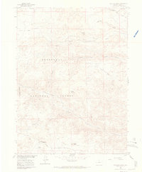
1960 Map of Haystack Gulch
USGS Topo · Published 1968About this map
Log Cabin serves as a lone point of settlement in this high-altitude landscape of northern Larimer County, where the sprawling Roosevelt National Forest meets the open Prairie Divide. The drainage network is particularly detailed, tracing the complex forks of North Fork Rabbit Creek, Middle Fork Rabbit Creek, and South Fork Rabbit Creek as they cut through the foothills. This 1960 survey illustrates a region defined by remote landmarks like Sheep Mountain and Haystack Butte, as well as the localized industry at Sloans Quarry. Genealogists and local historians can locate early public infrastructure like the Lone Pine Sch and follow the route of Red Feather Road across the divide. The presence of numerous named canyons and holes, such as Hole Canyon and Stuart Hole, highlights the importance of specific topography for early navigation and land use in this part of Colorado.
Find a feature on this map
23 named features on this map. Tap any name to fly to it.
Don’t see what you’re looking for? This feature index may not catch every label — zoom into the map to look around manually.
Map Details
Editions of this 1960 Haystack Gulch Map
4 editions found
Other maps of this area

1907 · Livermore
USGS Topo · 1:125,000

1909 · Livermore
USGS Topo · 1:125,000

1916 · Home
USGS Topo · 1:125,000

1920 · Home
USGS Topo · 1:125,000

1954 · Greeley
USGS Topo · 1:250,000

1957 · Greeley
USGS Topo · 1:250,000

1958 · Greeley
USGS Topo · 1:250,000

1960 · Haystack Gulch
USGS Topo · 1:24,000

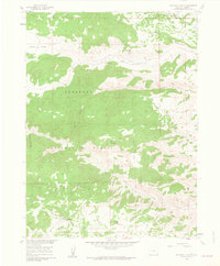
1960 · Livermore Mountain
USGS Topo · 1:24,000

1961 · Greeley
USGS Topo · 1:250,000