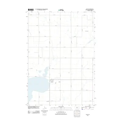
2012 Map of Hayti
USGS Topo · Published 2012About this map
Hayti serves as the focal point of this Hamlin County survey, which reveals the grid-like precision of the South Dakota prairie during the early 21st century. The landscape is defined by the expansive Lake Marsh, which dominates the southwestern portion of the quadrangle. As the terrain rises toward the east, it enters The Coteaus, a region of glacial hills that introduces subtle elevation changes to the otherwise flat agricultural plains. For those researching local heritage, the map provides precise locations for two notable burial grounds: Pleasant View Cem situated just east of the village center and West Norden Cem located further south. This edition emphasizes the structured county road network, dominated by numbered avenues and streets that facilitate the region's agricultural economy and connect the outlying farmsteads to the central hub of Hayti.
Find a feature on this map
25 named features on this map. Tap any name to fly to it.
Don’t see what you’re looking for? This feature index may not catch every label — zoom into the map to look around manually.
Map Details
Editions of this 2012 Hayti Map
This is the sole edition of this map. No revisions or reprints were ever made.
Other maps of this area

1953 · Watertown
USGS Topo · 1:250,000

1958 · Watertown
USGS Topo · 1:250,000

1969 · Hayti
USGS Topo · 1:24,000

1969 · Castlewood
USGS Topo · 1:24,000

1969 · Lake Norden
USGS Topo · 1:24,000

1969 · Pelican Lake
USGS Topo · 1:24,000

1969 · Watertown SE
USGS Topo · 1:24,000

1969 · Lake Poinsett
USGS Topo · 1:24,000

1973 · Bryant NE
USGS Topo · 1:24,000
1973 · Gertson Slough
USGS Topo · 1:24,000