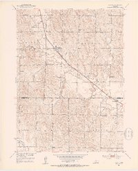
1951 Map of Hazard
USGS Topo · Published 1953About this map
Hazard and Sweetwater anchor this central Nebraska landscape along the valley of Mud Creek, where the Chicago Burlington and Quincy railroad cuts a diagonal path through the prairie. The map reveals a high density of rural schoolhouses, including Pleasant Hill Sch, Bloody Run Sch, and Brock Sch, illustrating the structured social fabric of Sherman and Buffalo counties during the mid-century. A network of local roads and watercourses like Bloody Run and Dry Pleasant Creek define the agricultural drainage patterns, while the Hazard Cem and a small Landing Strip near the Litchfield Recreation Grounds provide specific points of interest for genealogists and local historians. The survey reflects the post-war development of the Missouri River Basin, detailing a landscape of modest settlements and meticulously placed school districts.
Find a feature on this map
24 named features on this map. Tap any name to fly to it.
Don’t see what you’re looking for? This feature index may not catch every label — zoom into the map to look around manually.
Map Details
Editions of this 1951 Hazard Map
3 editions found
Other maps of this area

1896 · Kearney
USGS Topo · 1:125,000

1896 · Wood River
USGS Topo · 1:125,000

1899 · Loup
USGS Topo · 1:125,000

1951 · Litchfield SW
USGS Topo · 1:24,000

1951 · Litchfield NE
USGS Topo · 1:24,000

1951 · Hazard
USGS Topo · 1:24,000

1951 · Litchfield
USGS Topo · 1:24,000

1953 · Ravenna NW
USGS Topo · 1:24,000

1953 · Ravenna
USGS Topo · 1:24,000

1955 · Broken Bow
USGS Topo · 1:250,000