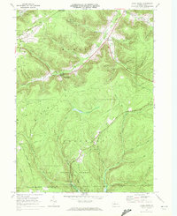
1969 Map of Hazel Hurst
USGS Topo · Published 1972About this map
Hazel Hurst sits at the heart of this late-1960s study, where the industrial legacy of the McKean and Elk County borderlands is written into the hills. The landscape is defined by its transit history, following the winding Baltimore and Ohio Railroad and various stretches of Old Railroad Grade that once hauled timber and minerals through the Allegheny plateau. A sprawling Gas Field occupies much of the western terrain, interspersed with deep hollows like Shetland Hollow and Stone Dock Hollow. To the south, the timbered expanses of Elk State Forest and State Game Lands No 62 represent the conservation of this high-elevation backcountry. Settlement patterns are focused along narrow valley floors, with small hubs at Marvindale and Williamsville established near the headwaters of the Clarion River and Marvin Creek.
Find a feature on this map
38 named features on this map. Tap any name to fly to it.
Don’t see what you’re looking for? This feature index may not catch every label — zoom into the map to look around manually.
Map Details
Editions of this 1969 Hazel Hurst Map
This is the sole edition of this map. No revisions or reprints were ever made.
Other maps of this area

1924 · Bradford
USGS Topo · 1:62,500

1926 · Bradford
USGS Topo · 1:62,500

1933 · Smethport
USGS Topo · 1:62,500

1935 · Mt. Jewett
USGS Topo · 1:48,000

1937 · Smethport
USGS Topo · 1:62,500

1940 · Mt. Jewett
USGS Topo · 1:62,500

1941 · Bradford
USGS Topo · 1:62,500

1944 · Bradford
USGS Topo · 1:62,500

1948 · Crosby
USGS Topo · 1:62,500

1948 · Wildwood Fire Tower
USGS Topo · 1:24,000
Featured Places
- Mount Jewett, PA
- Jones Township, PA
- Hamlin Township, PA
- Sergeant Township, PA
- Williamsville, Sergeant Township